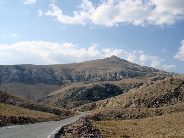
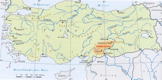
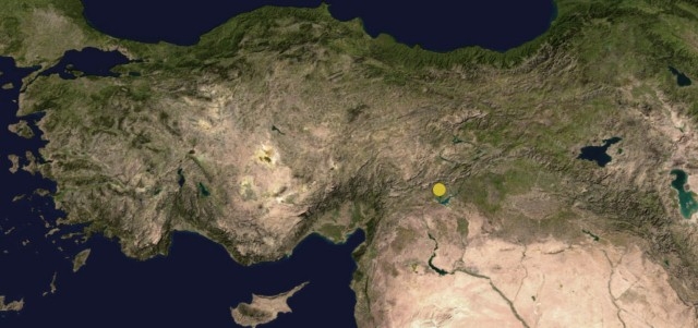
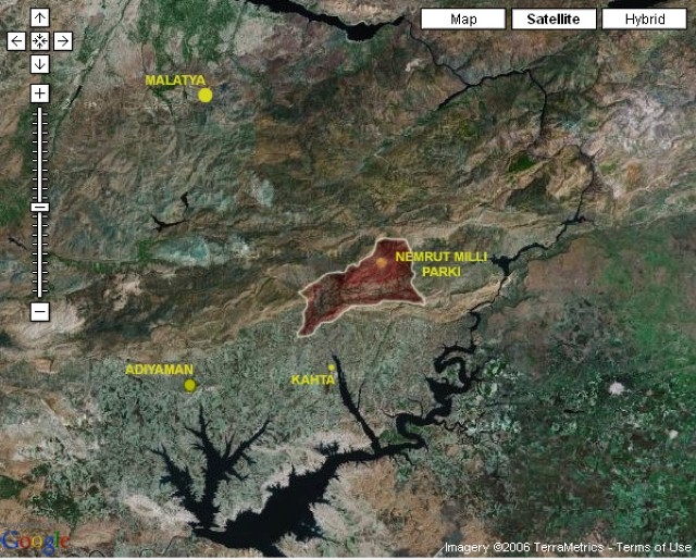
The Hierothesion of Mount Nemrut, located on one of the important crossing points on the Upper Euphrates valley, was constructed during reign of King Antiochus I, who ruled during the most prominent period of the Commegene Kingdom [163(?) or 80(?)BC – 72 AD]. The kingdom’s boundaries spread from Kahramanmaraş to the west and Malatya and the Taurus Mountains to the north. Today, the Tumulus of Mount Nemrut is located in the town of Kahta within the boundaries of Adıyaman Province.
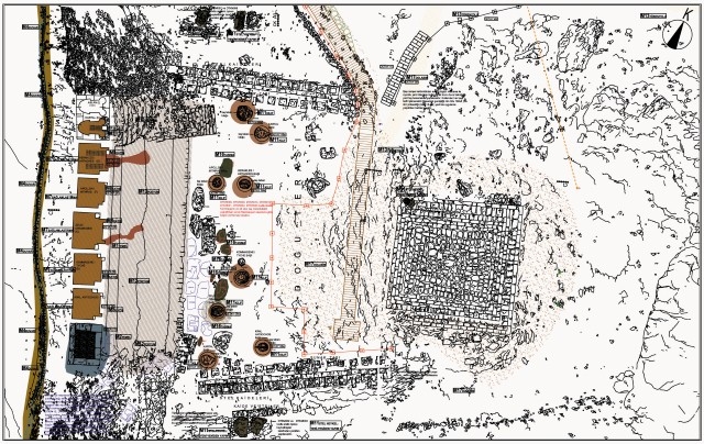
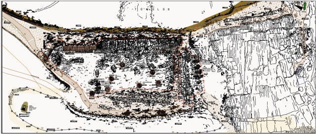
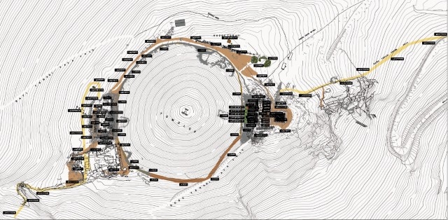
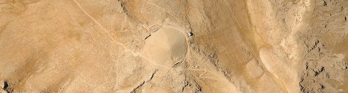
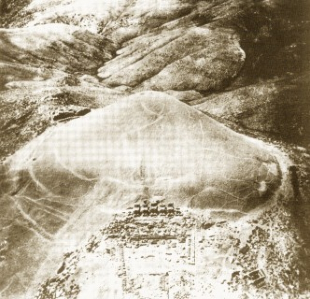
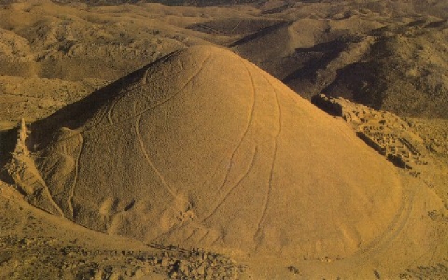
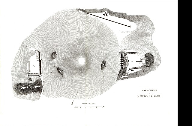
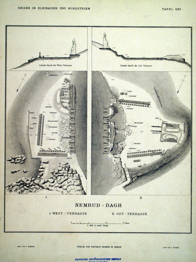
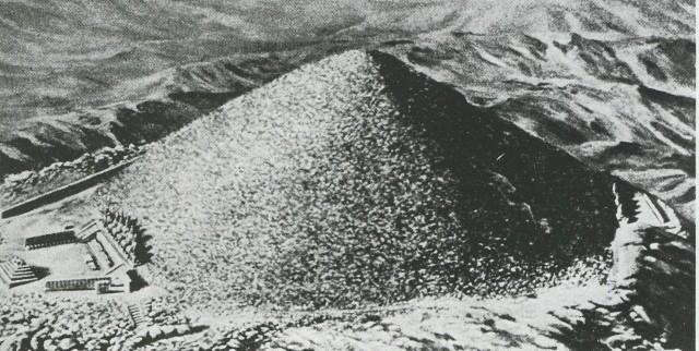
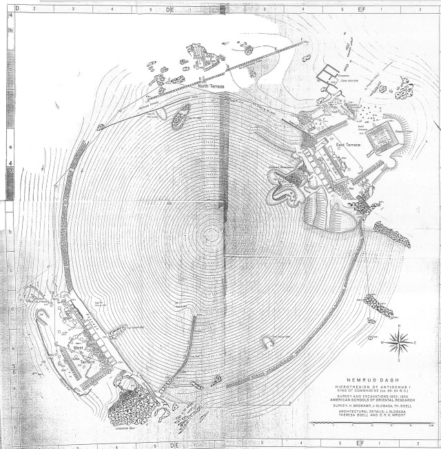
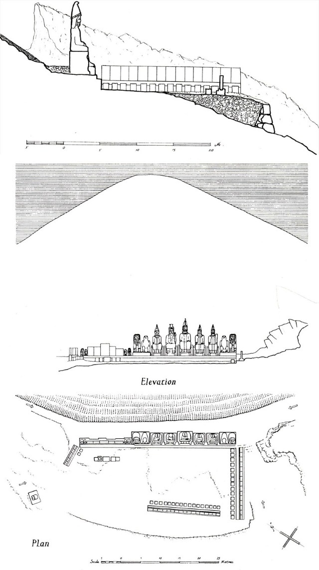
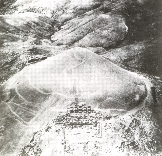
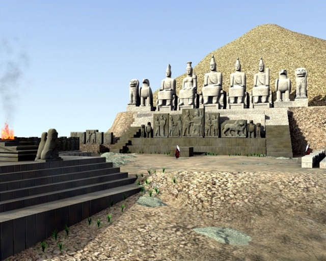
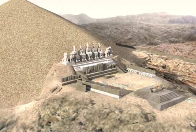
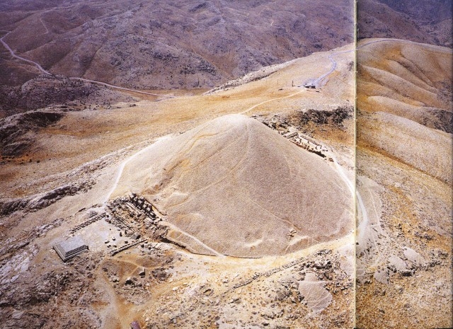
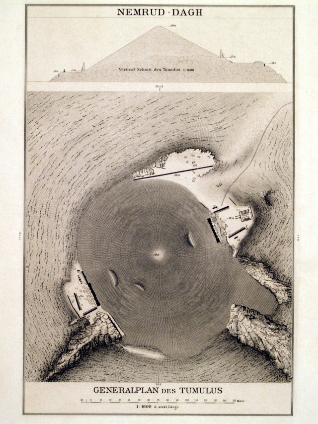
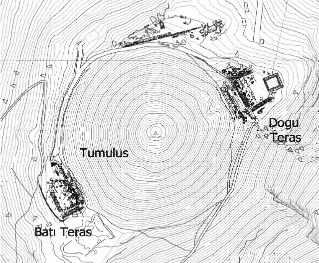
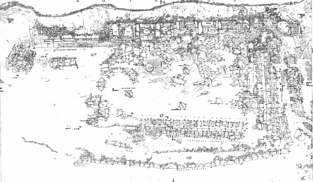
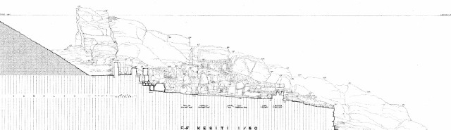
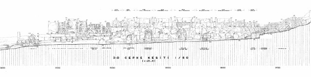
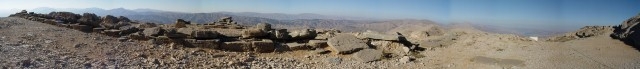
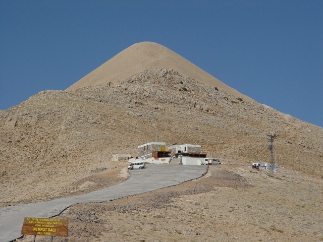
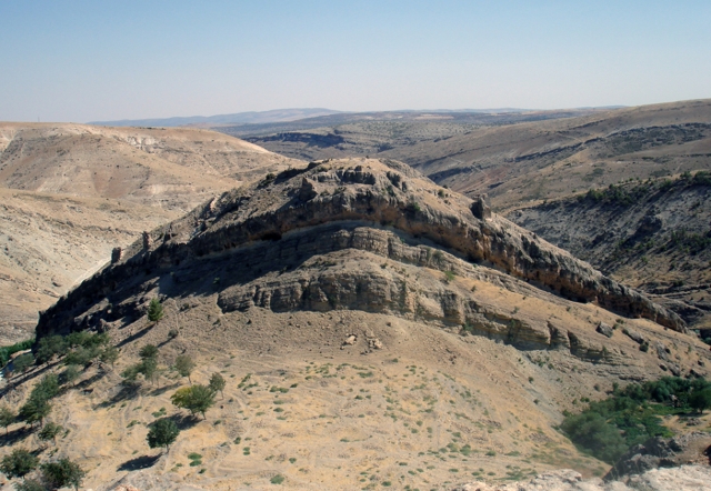
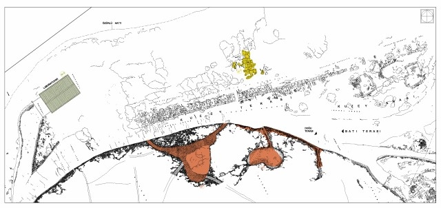
Spread over an area of 2.6 hectars (26.000m2), the Hierothesion is comprised of a conical tumulus sloped at 30-35 degrees at the center, and three terraces surrounding it on the west, east and north sides, together with processional ways leading to the tumulus from the northeast and the southwest. The highest point of the tumulus is at 2206 m, while its diameter is 145 m. The east and west terraces are alike, however the north terrace is completely different from those two.
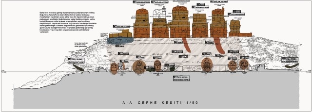
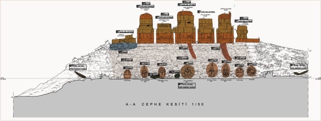
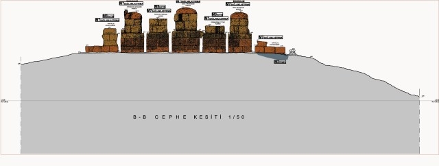
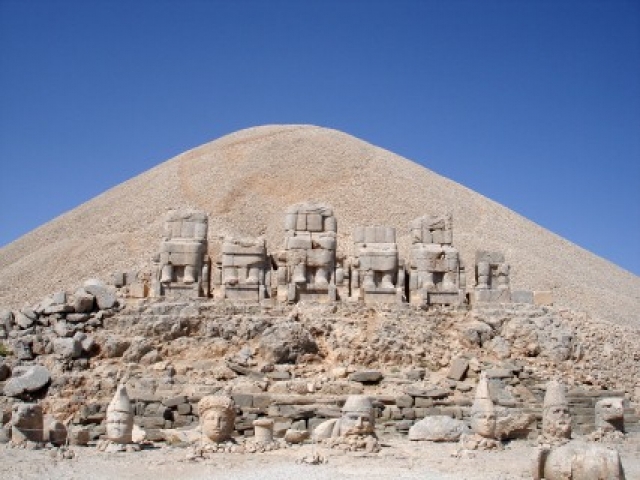
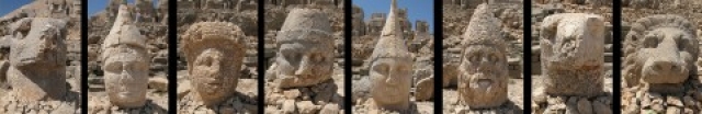
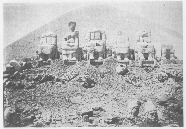
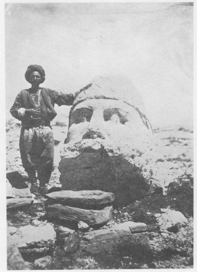
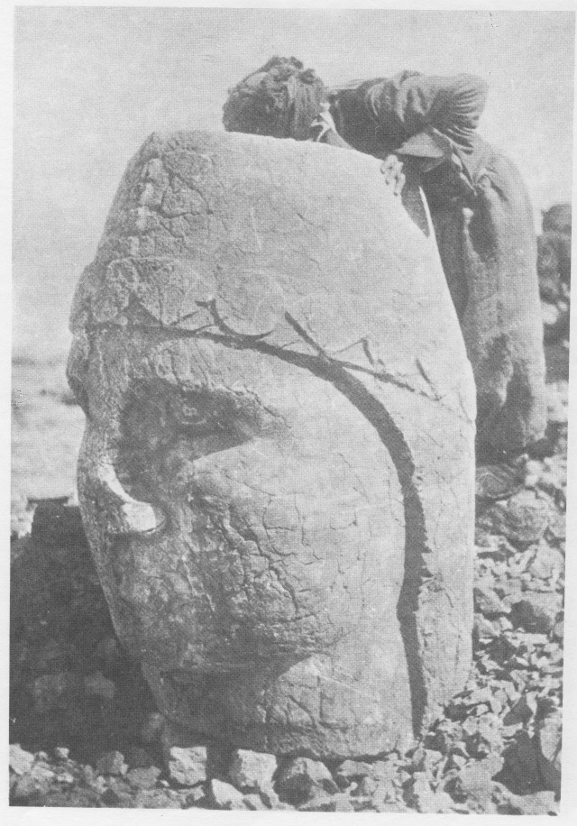
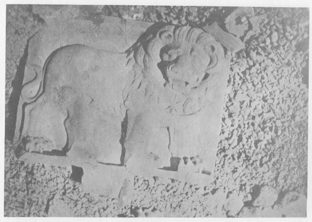
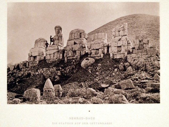
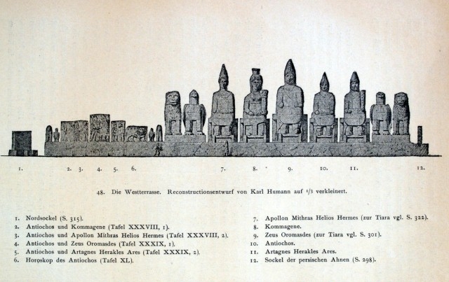
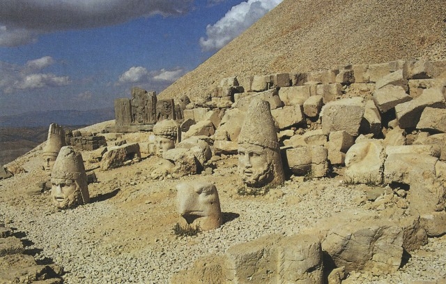
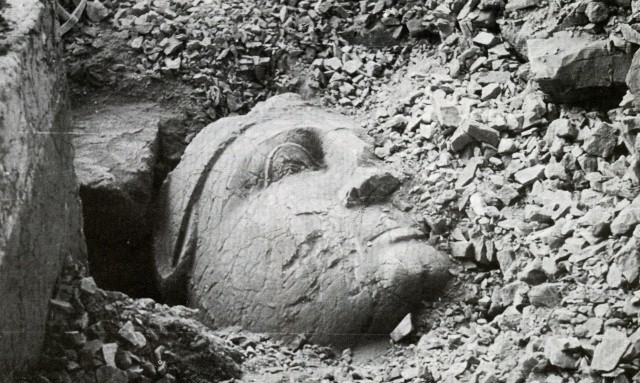
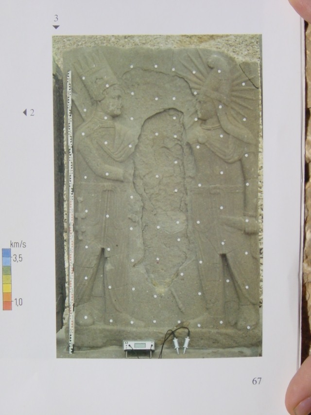
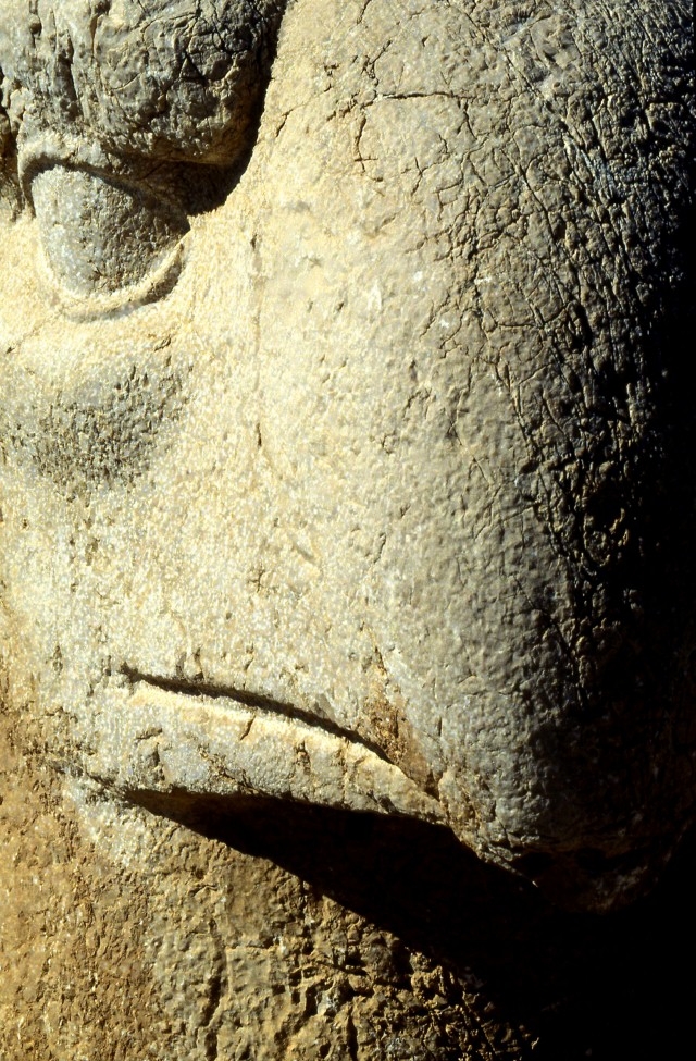
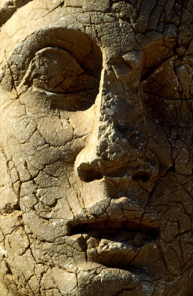
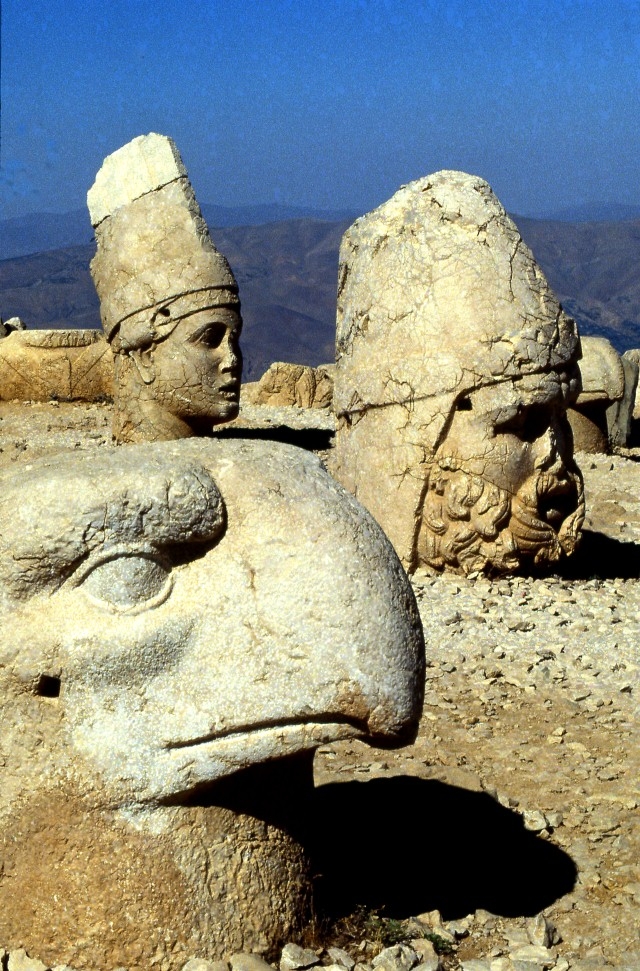
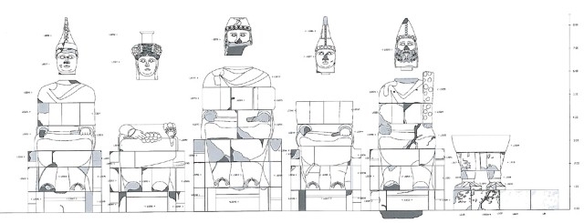
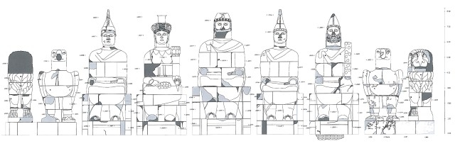
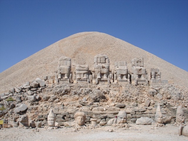
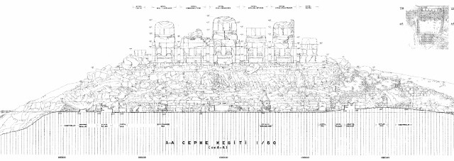
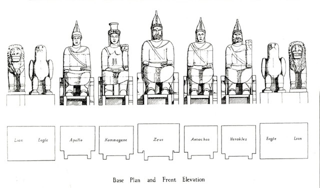
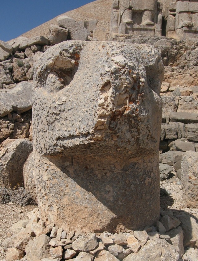
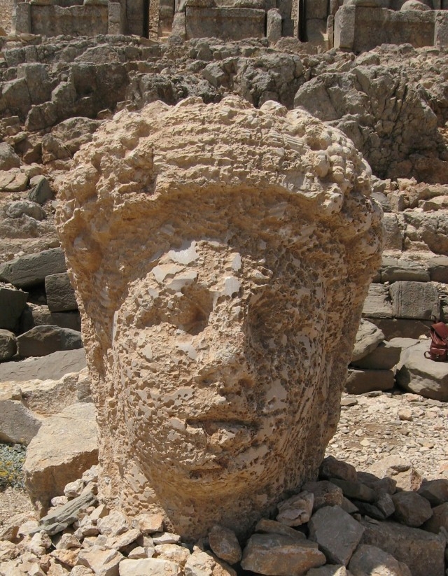
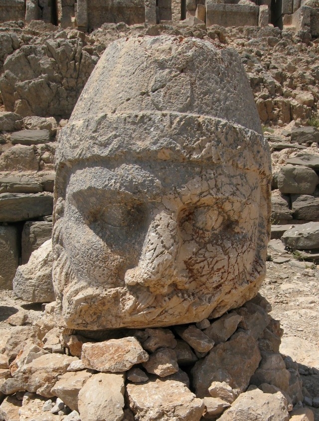
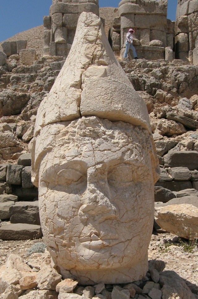
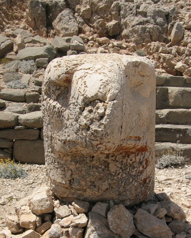
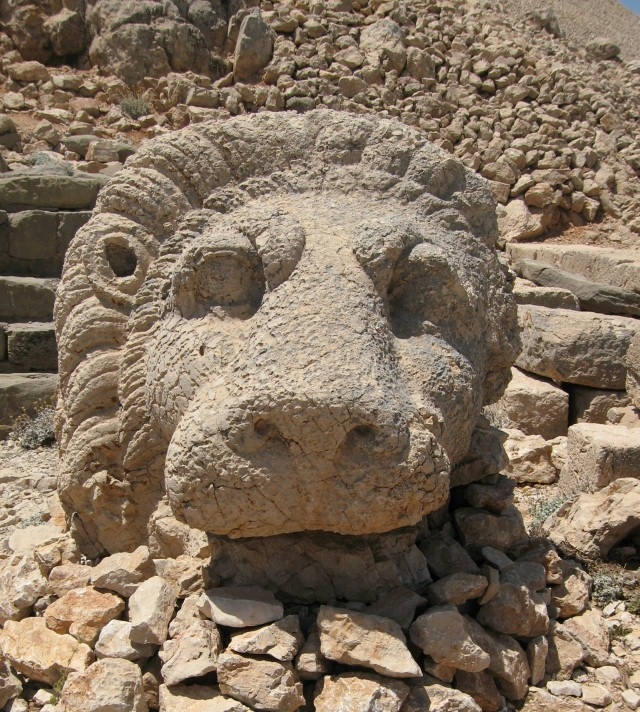
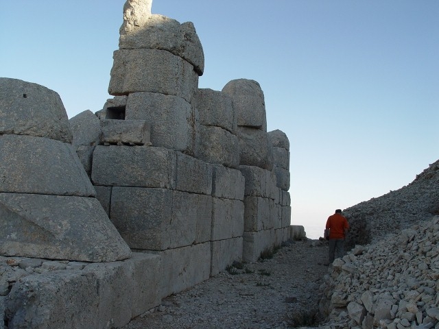
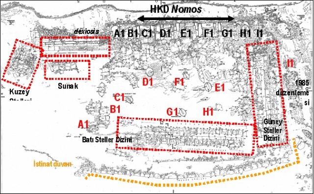
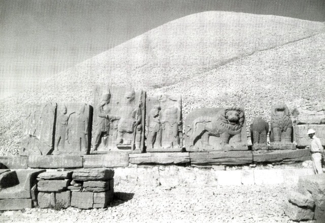
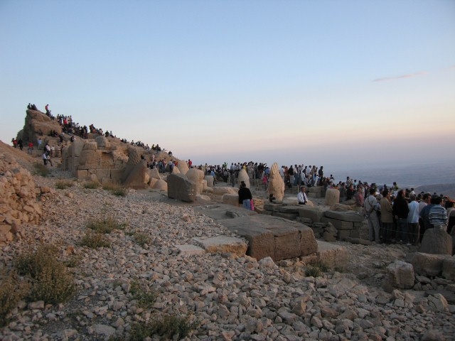
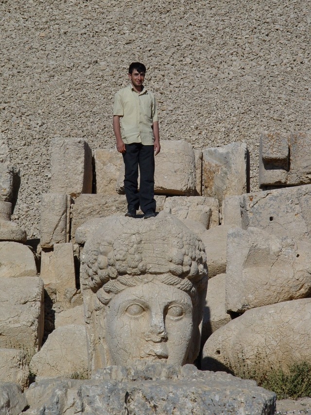
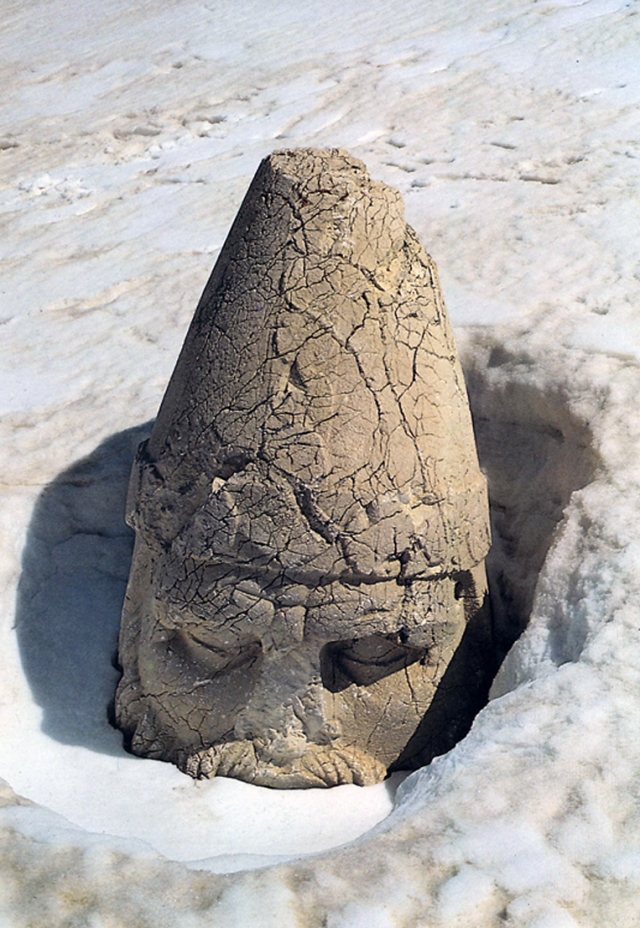
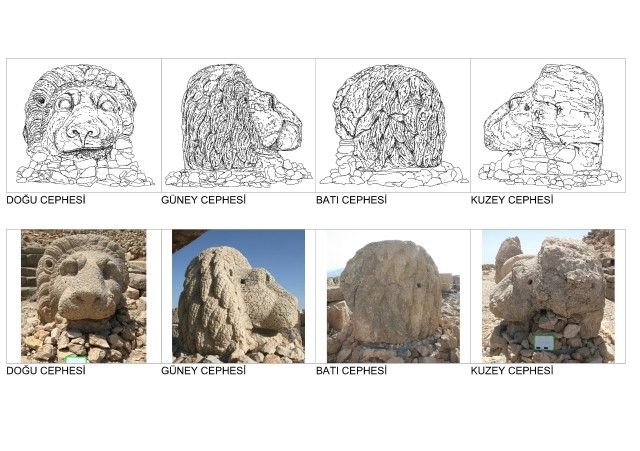
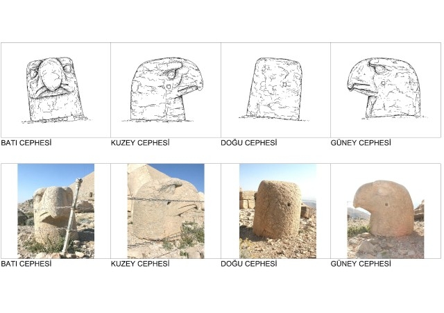
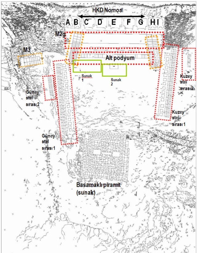
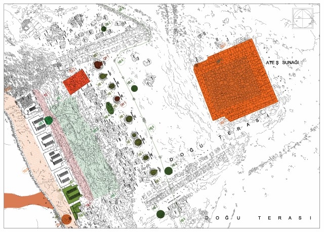
In the east and west terraces, there are five limestone god statues with their backs turned to the tumulus, flanked by guardian animals, lions (A and I) and eagles (B and H), on each side. In each of these terraces, the gods situated between the guardian animals are, from left to right: Antiochus (C), Commagene/ Tyche (D), Zeus/ Oromasdes (E), Apollon/ Mithras-Helios-Hermes (F) ve Herakles/ Artagnes-Ares (G).
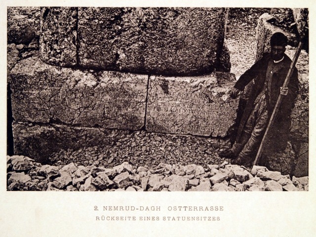
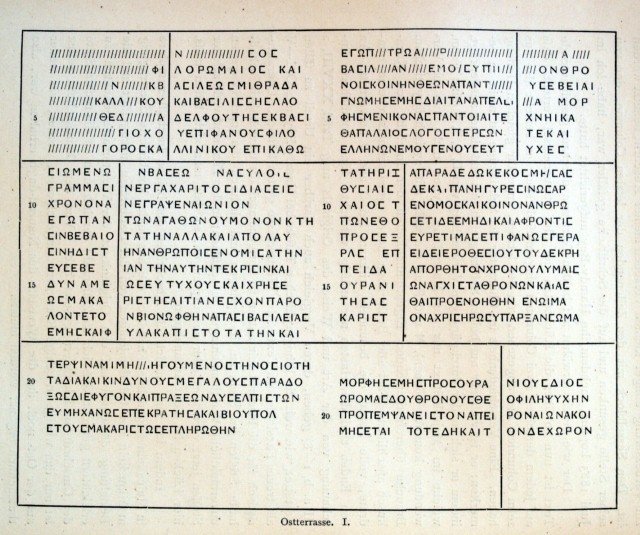
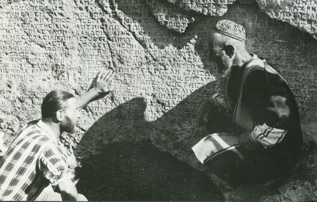
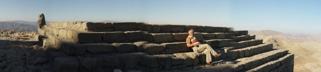
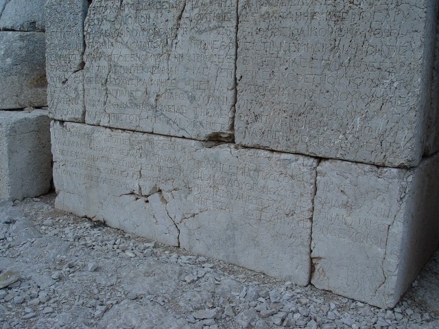
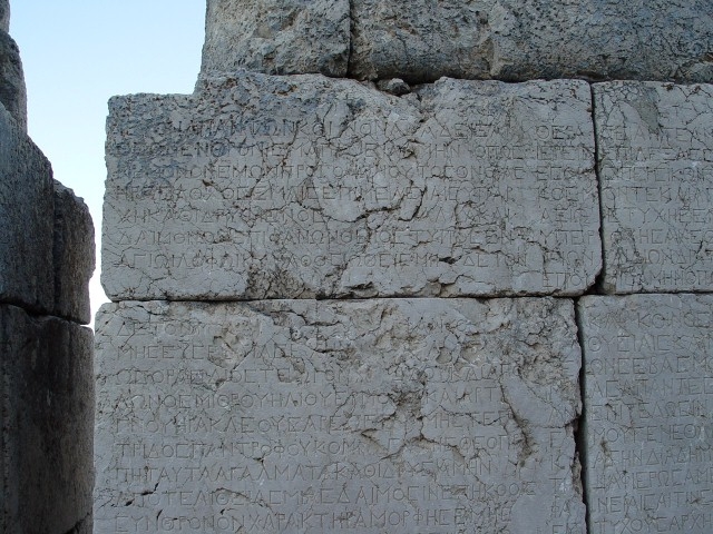
At the back of the statues, identical in both terraces, is Antiochus’ will (nomos), which is inscribed in ancient Greek, on which the gods are referred to with their Greek and Persian names. Besides the colossal statues in the terraces, there are stelae plinths in front of the altars, situated symmetrically in the east terrace, and along the width of the terrace in the west terrace due to its narrowness.
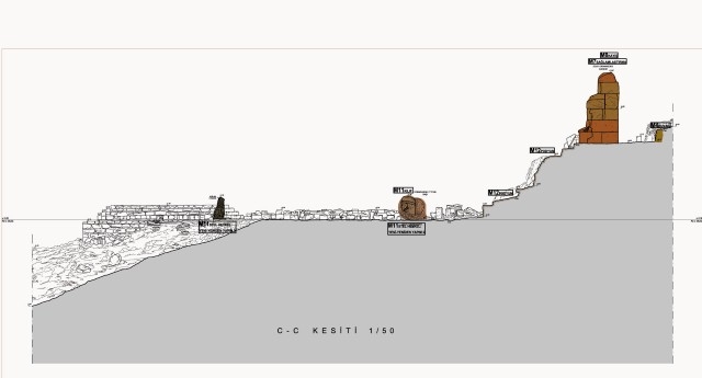
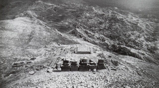
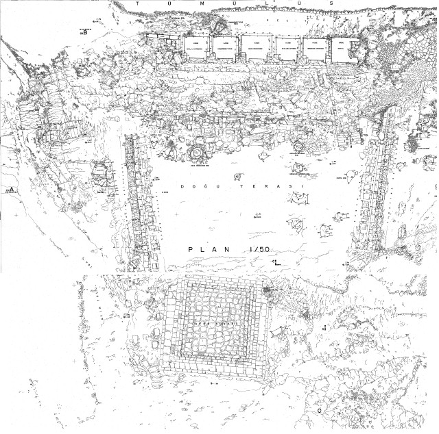
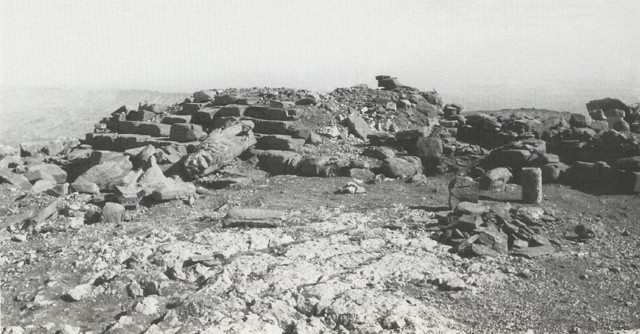
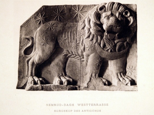
In the east terrace, there is a square platform, which Goell refers to as the stepped pyramid, but other researchers prefer to call the altar. In the west terrace, there is a series of stelae with dexiosis scenes and the Lion Horoscope, which is assumed to show the date of construction of the tumulus.
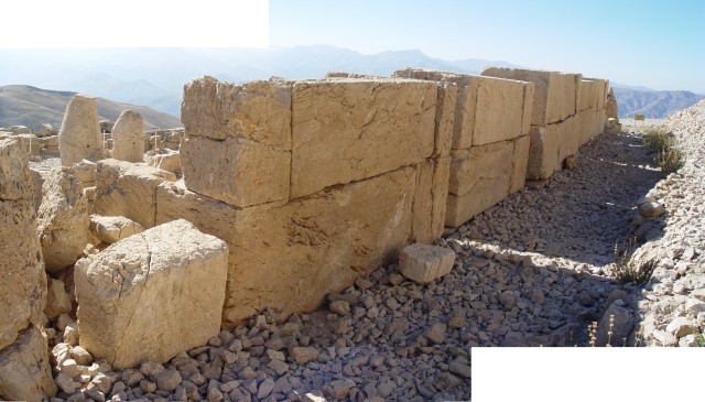
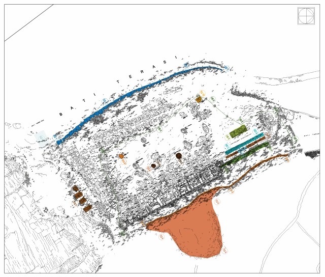
The north terrace, situated to the northwest of the tumulus, is like a narrow rectangle and contains sandstone plinths. Next to these plinths lie collapsed stelae which bear no inscriptions or reliefs. There are two gaps in the plinth series of the north terrace, one of which – the one on the west – is interpreted by Goell as the entrance gate to the site from the Processional Way.
UNESCO Documents
Mount Nemrut Tumulus is one of the sites in Turkey inscribed into the UNESCO World Heritage List. The World Heritage List, which started to be made in 1978, currently (2015) includes 1007 monuments/sites from different countries, 197 of them are natural, 31 of them are mixed (natural & cultural) and 779 of which are listed as cultural properties (http://whc.unesco.org/en/list/).
Mount Nemrut Tumulus was included on the prestigious UNESCO World Heritage List in 1987 on the basis of criteria I, III and IV, with the reference number 448. Features that ensure Mount Nemrut Tumulus to be listed as a World Heritage are:
“Being an important ensemble of architectural and sculptural monuments bearing witness to the fusion of Persian, Hellenistic and Anatolian traditions of styles; its complex design and colossal scale combined to create a project unequalled in the ancient world; the high technology used which was seen nowhere else in that age”.
The web address http://whc.unesco.org/en/list/448 of the UNESCO World Heritage List presents a short definition of Nemrut and its location with few photographs in the gallery. The short definition given there is shown below:
NEMRUT DAĞI
![]() Turkey
Turkey
Date of Inscription: 1987
Criteria: (i)(iii)(iv)
Property: 13850 ha
Adıyaman İli
N38 02 11.8 E38 45 49.3
Reference Number: 448
Brief Description
The mausoleum of Antiochus I (69–34 B.C.), who reigned over Commagene, a kingdom founded north of Syria and the Euphrates after the breakup of Alexander’s empire, is one of the most ambitious constructions of the Hellenistic period. The syncretism of its pantheon, and the lineage of its kings, which can be traced back through two sets of legends, Greek and Persian, is evidence of the dual origin of this kingdom’s culture.
There are three main documents on Nemrut in the website of UNESCO World Heritage Centre, under the title “Documents” (http://whc.unesco.org/en/list/448/documents/). The names and contents of these documents can be obtained here.
3.1.1.2. Legal Status
Here you can find information and documents on the national and international status of the Tumulus of Mount Nemrut. Related national and international documents and decisions are given below in chronological order (in Turkish).
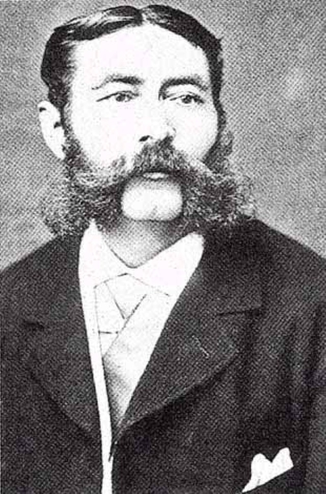
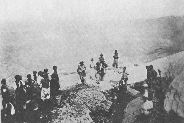
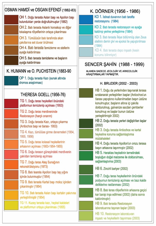
The Anatolian Kingdom of Commagene, which is not mentioned in ancient sources, did not attract researchers’ attention until the discovery of the cult area (Hierothesion) at Mount Nemrut in 1881. After the discovery of the Tumulus of Mount Nemrut by Karl Sester in 1881, Nemrut and the Commagene Kingdom became a research topic for many scholars and scientists, both Turkish and foreign, followed by excavations and restoration work at Nemrut and publications concerning their results. These studies were compiled in the Nemrut archive established by METU within the context of CNCDP and are presented chronologically below.
1881, Karl Sester and Otto Puchstein: Discovery of the Tumulus
This sacred place (Hierothesion) at Mount Nemrut was first discovered in 1881 by Karl Sester. After this discovery, with the information provided by Sester, the Nemrut Tumulus attracted the attention of German authorities, leading to the first investigation by the archaeologist Otto Puchstein and Karl Sester in 1882.

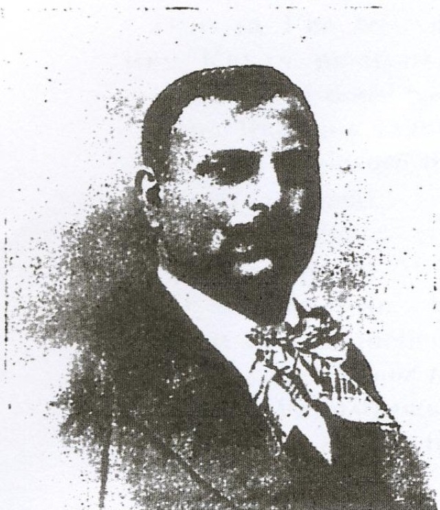
1882, Osman Hamdi Bey and Osgan Efendi: The First Turkish Team at Nemrut
Osman Hamdi Bey, appointed as the director of Müze-i-Hümayun (Museum of the Ottoman Empire) in 1881, and Osgan Efendi, sculptor and instructor at Sanayi-i Nefise Mektebi (School of Fine Arts), were assigned, as part of an Ottoman mission in 1882, to study the monuments of Mount Nemrut and shed light on various questions on this subject. The authors presented the results of their research, which included partial excavations and comparisons with the findings of Puchstein, in the French publication “Le Tumulus de Nemroud Dagh” (1st edition 1883, 2nd edition 1987).

1882, Karl Humann and Otto Puchstein: From Anatolia to North Syria
In June 1882, the same year as Osman Hamdi Bey and Osgan Efendi, Karl Humann and Otto Puchstein travelled to Nemrut to conduct research (Dörner, 1999: 32, 40). The latter two published the results of their research on the Commagene region and archaeological findings in northern Syria in the two volume work entitled “Reisen in Kleinasien und Nordsyrien-ausgeführt im Auftrage der Kgl. Preussischen Akademie der Wissenschaften, beschrieben von Karl Humann und Otto Puchstein” (Travels in Anatolia and Northern Syria—An Assignment of the Prussian Royal Academy. Related by: Karl Humann and Otto Puchstein) in 1890, almost 10 years after their field research. These two volumes cover research conducted at Mount Nemrut between 1882 and 1883. We would like to thank Istanbul German Archaeological Institute and Prof. Scott Redford for providing us a copy of this book.


Research interrupted
After Humann and Puchstein’s publication in 1890, research concerning Mount Nemrut and Commagene was interrupted for many years. Field research focusing on Mount Nemrut did not recommence until the establishment of the Turkish Republic (1923), even until 1938. However, beginning in 1896, certain researchers did publish their various studies on Antiochus’ Hierothesion (Sanders, 1996: 30-31).
1954-1958 and 1984, Karl F. Dörner at Nemrut
Starting from 1936-37, Dörner became interested in Nemrut, and in 1938 he conducted research with the architect R. Naumann. The two young researchers published the results of their investigations under the name of “Forschungen in Kommagene” (Research in Commagene) in 1939 (Dörner, 1999: 138-149). In 1951, after World War II, Dörner returned to the region. Dörner’s priority was to excavate Arsameia, while his interest Nemrut continued. In the same year, an American team comprising Theresa Goell and Albrecht Goetze arrived at Nemrut. These two groups agreed to carry out collaborative research at Mount Nemrut and Arsameia (Dörner, 1999: 178). Subsequently, Dörner and Goell worked together at Nemrut from 1953 to 1956 uninterruptedly, and for the last time in 1958.
In 1984, certain repairs were implemented at Nemrut by Dörner, a group of German researchers and experts from the Ministry of Culture and Tourism. In 1984, Dörner’s (1911-1992) health declined and this was his last active year at Nemrut.
Dörner related his research at Nemrut and Arsameia in various articles and publications. The most important among these was ““Kommagene-Götterthrone und Königsgraber am Euprat–Neue Entdeckungen der Archaologie“ (1981). In 1987, the expanded edition of this work entitled “Der Thron der Götter auf dem Nemrud Dağ” was translated into Turkish and published by the Turkish History Institution (Türk Tarih Vakfı).
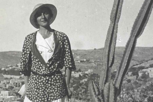
1956-1973, Queen of the Mountain: Theresa Goell
Goell (1901-1985) became interested in Mount Nemrut after 1939 and she arrived at Mount Nemrut for the first time in 1947, followed by another visit in 1951 (Sanders, 1996: XXIII, XXIV). She worked with Dörner between 1951-1956; later, in 1958, 1961, 1963, 1964 and 1967 she worked at Nemrut and Dörner’s excavations at Arsameia.
During the first years of her research, Goell focused primarily on excavation and documentation work, while between 1954 and 1956, she carried out excavations in search of Antiochos’ tomb inside the tumulus (Sanders, 1996: 44, 47). Unsuccessful in these attempts, Goell continued with geophysical research at Nemrut in 1961 and Samsat excavations between 1964-1974. In 1973, Goell restored the fire altar but she could not continue working at Nemrut due to her age and various health problems.
Until her death at the age of 84, Goell was able to publish only a few articles about Nemrut. In 1983, she asked Donald H. Sanders to compile the results of her work (Sanders, 1996: XVII). After 13 years of meticulous work, Sanders compiled Goell’s work and prepared a two-volume work in English entitled “Nemrud Dağı:The Hierothesion of Antiochus I of Commagene” published in 1996. This work is the most comprehensive publication on Nemrut to this day.


1958, Ara Güler at Nemrut with a French television
During the filming of a documentary on civilizations by a French television, Ara Güler, with prior knowledge of the existence of the Nemrut Tumulus, suggests that they film the Tumulus of Mount Nemrut, and accompanies them to the tumulus, where he takes his own photographs. News of this visit in 1958 is published by more than 100 arts and news magazines throughout the world, especially in Germany and France. (Kürkçüoğlu, S. S., 2002, http: //www.hezarfen.net/paralax/056sabri.htm).
Prof. Dr. Sencer Şahin Şahin (1939-2014), Dörner’s student, conducted petrographic research at one monument under the guidance of Dr. B. Fitzner from the Aachen Technical University during the first season of field work in 1987. Later, Şahin carried out geophysical research to determine the location of the tomb chamber and worked on the reconstruction and presentation of the site. Şahin and German researchers presented the results of their research at many venues. Another important contribution of Şahin is the translation of the nomos of King Antiochos I into Turkish, which was published in 1998 under the name “Tanrılar Dağı Nemrut / Mountain of the Gods”.
1990, İbrahim Demirel at Nemrut
In 1990, the photographer Ibrahim Demirel travelled to the region and visited Mount Nemrut too. As a result of this visit, Demirel’s archives now contain approximately 250 color slides including photographs of most of the sculptures and their details. The METU-CNCDP team extends many thanks to Mr. Demirel who permitted some of his photographs to be presented in this website.
Publications and documentaries on Nemrut
Publications on Nemrut began to increase toward the 1990’s with special attention from Arkeoloji ve Sanat Yayınları / Archeology and Art Publications directed by Nezih Başgelen. The first publication on Nemrut after the establishment of the Republic was the work of Osman Hamdi Bey and Osgan Efendi in 1883, a French book entitled “Le Tumulus de Nemroud Dagh”, which was reprinted in 1987. This publication has not yet been translated into Turkish.

This book was followed by the translation F.K. Dörner’s second edition of “Der Thron der Götter auf dem Nemrud Dağı” (1987) into Turkish by Vurak Ülkü, which was published by the Turkish History Institution (Türk Tarih Kurumu) with the title “Nemrud Dağı’nın Zirvesinde Tanrıların Tahtları” in 1990.
In 1998, Arkeoloji ve Sanat Yayınları also began to publish other books on Nemrut including several written or edited by Nezih Başgelen, such as “Tanrılar Dağı Nemrut / Mountain of the Gods” (1998), “Havadan Nemrut / Nemrut from the Air” (2000) and “Nemrut Dağı, Keşfi, Kazıları, Anıtları / Mount Nemrut, its Discovery, Excavations and Monuments” (2003). Gülcan Acar also edited a book entitled “Nemrud” (2004) which contains her own photographs.
Among these, those most important publications about the history of research at Nemrut include “Tanrılar Dağı Nemrut / Mountain of the Gods” (1998) edited by archaeologist Nezih Başgelen, which contains the Turkish translation of the Nomos and “Havadan Nemrut / Nemrut from the Air” (2000) which documents Nemrut with aerial photographs.


2001-2003, Herman Brijder and Maurice Crijns: Crijns’ passion for Nemrut
Crijns, who became interested in MountNemrut after 1980s, established the International Nemrud Foundation (INF) in 1998. In 2000, Nemrut was inscribed on the “World Monuments Watch List of 100 Most Endangered Sites”, a list issued by the World Monuments Fund (WMF) every two years. A year later, WMF declared its support for INF’s Nemrut Project. The same year, INF signed an agreement with Prof. Brijder from the University of Amsterdam, appointing him as project director for Nemrut. In 2001, a team directed by Brijder and Crijns was granted permission for research with the support of INF. Between 2001-03, the team carried out documentation and research in Nemrut. 2001 works, carried out in collaboration with WMF, were published as “Mission Report 2002”. However, after October 2002, WMF officially withdrew from the project. Brijder-Crijns team continued its research at Nemrut between 2002 and 2003, but its permission was cancelled in 2004 by the Ministry of Culture and Tourism based on the decision of the Adana Conservation Council which promulgated a holistic approach to MountNemrut.


Documentaries and virtual simulation based visual material and films
Besides research, excavations and restoration work supervised by the Ministry of Culture and Tourism, various independent groups have also produced various publications, documentaries as well as visual material and films on Nemrut based on virtual simulation.
Throne of the Gods Nemrut
This documentary, prepared by director Tolga Örnek in 2000, was sponsored by Türkiye İş Bankası (Türkiye İş Bank), supported by İstanbul Menkul Kıymetler Borsası (İstanbul Stock Exchange) and Çalık Holding and produced by Ekip Film. This film, which includes old views from Goell’s archive as well as interviews with researchers such as Donald H. Sanders and Sencer Şahin, stands out as the most comprehensive documentary on MountNemrut. It has received three important awards:
- 2001 International Film and Video Festival (USA) (First place in History and Biography),
- 2001 Avşa Film Festival (Documentary, first place),
- 2002 Torento Film Festival (Rai Television Award).
Three-dimensional views prepared by Learning Sites, Inc.
The film “Tanrıların Tahtı Nemrut” (Throne of the Gods Nemrut) incorporates original visual material to make a virtual simulation of the Tumulus of Mount Nemrut by the American firm Learning Sites Inc. based on Donald H. Sanders’ research on Theresa Goell’s archives. Learning Sites Inc., founded towards the end of the 1980’s in the United States, is a pioneer in applying digital realism to archaeological sites and specializes in creating reliable archaeological visualization for interactive education and research. (http://www.learningsites.com/Frame_layout01.htm).
Hidden Tomb of Antiochus
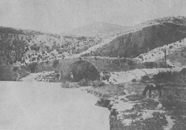
This documentary, filmed in 2000 by Digital Ranch of California for the American History Channel was first televised in 2001. It was directed by Laura Verklan, with Tufan Turanlı as the cameraman. This film presented Antiochos I and his mausoleum, as well as Arsameia, the CendereBridge and AdıyamanMuseum, together with Zeugma and Şanlıurfa as settlements within the Commagene region. ( http://tv.nytimes.com/show/49845/Hidden-Tomb-of-Antiochus/overview)
A short film presented at the EXPO 2000 Fair
The main theme of the Turkish Pavilion prepared by the Turkish Ministry of Tourism for the EXPO 2000 Fair in Hannover was the Tumulus of Mount Nemrut; however the virtual simulation of Nemrut was not based on any scientific research. The Turkish pavilion was designed and executed by INFOTRON ( http://www.infotron.com.tr/kurumsal.html).
“Queen of the Mountain”
This documentary, directed by Martha Goell Lubell, relates the biography of Theresa Goell. Produced in 2005, it conveys Goell’s rebellion against limitations imposed by her family and the period, her interest in archaeology, followed by her visit to Commagene after the age of 50 and her personal devotion to Nemrut. This film, which includes visual material based on Goell’s archival films and virtual simulations, was shown at the Brattleboro Women’s Films Festival, and received the “best film” award at the Archaeology Channel Film and Video Festival.
Mount Nemrut Scientific Advisory Committee is established
After the suspension of research at Nemrut in 2004, the Mount Nemrut Scientific Advisory Committee (Nemrut Dağı Bilimsel Danışma Kurulu – NTBDK) was established by the Ministry of Culture and Tourism in June 2005, with the aim of guiding future work at Nemrut. The Committee defines future research to be carried out at the Tumulus of Mount Nemrut.
METU’s recommendation for a program concerning Nemrut…
In March 2006, taking into consideration the history and present condition of the Tumulus of Mount Nemrut, the Commagene Conservation Development Program (CNCDP) was prepared by METU, which defined necessary research and field work to be carried out in Nemrut at a macro scale, utilizing new legal devices. Presented to the Ministry of Culture and Tourism, the CNCDP was approved by the NTBDK on August 15, 2006 and a protocol was signed by the Ministry of Culture and Tourism and METU, initiating a new phase of research and field work in Nemrut.
Strategically important due to the presence of the Euphrates and Taurus mountain passes, the region between the Euphrates, Tigris and Nile rivers, mostly referred to as the Fertile Crescent and where Commagene Kingdom is located, has been inhabited from the Paleolithic period to the present day (Kökten, 1947: 469; Ataman, 1990: 197-207; Dignas & Filges, 1991: 7). As a region allowing access to the Anatolian Plateau from Northern Syria and Upper Mesopotamia, it has always been the target of dominant powers (Strabon, XI, 12.4, 11,14.2; Charlesworth, 1924: 76; Dignas & Filges, 1991: 7).
Emergence of the CommageneKingdom: 163(?)-72 BC
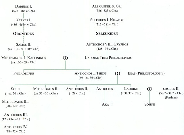
The region, a large part of which remains within the borders of the Province of Adıyaman, was ruled first by the Hittites (1650-1340 BC), later by the Hurri and Mitanni (1300-1200 BC), Late Hittite Principalities (1200-890 BC), Assyrians (850-605 BC) and the Babylonian Kingdom. The Kummuh-Kummuhu Kingdom, established after 1200BC, was considered the founder of the Commagene Kingdom from the 4th century BC onward. The region went under Seleucid rule between 305-63 BC (Appianos, Syria, 55, 62; XI, 8, 48-49). It is thought that, Ptolemaios, rebelling against the Seleucids in 163BC, established the Commagene Kingdom (Diadoros, XXXI, 19a; Sullivan, 1975: 31-42; Sanders, 1996: 19). After Ptolemaios, Samos II (130-100 BC), founder of the capital Samosata (Syme, 1995: 10, 41, 71; Mommsen, 1909: 349) and Mithradates Kallinikos I (c. 100-69 BC) were able to defend their state through political marriages with the Seleucids, in the south, and the Parthians, in the east (Dignas & Filges, 1991: 9). Mithridathes Kallinikos I, related to the Macedonian Alexander the Great on his maternal side and the Persian King Darius on his paternal side, gave his kingdom the name Commagene, meaning “community of genes” in ancient Greek, in reference to the unity of the beliefs, culture and traditions of their eastern and western forefathers (Dörner, 1975: 27; Wagner, 2000: 1).
The Period of King Antiochos I: 69-36 BC
King Antiochos I, who succeeded Mithradates I, elevated the CommageneKingdom to its highest economic and cultural level despite vexing political relations between the Roman and Parthian Empires. The monumental tombs constructed at MountNemrut and in Arsemia are edifices of this period. During this period, the CommageneKingdom, acquiring the title “Friend of the Romans” due to its support for the Roman Consul, attained its widest borders. Commagene, known for its fertile lands during the ancient period, spread until Kahramanmaraş, Göksun and Pınarbaşı to the west and Malatya and the Taurus Mountains to the north, and extended as far as Upper Mesopotamia and the west side of the Upper Euphrates, the Euphrates river to the east, and Nizip and Antakya to the south.
After King Antiochos I
After King Antiochos I, Commagene was ruled by Mithradates II (36-20 BC) and Antiochos III (20 BC-17 AD) and reached its second brilliant period from a military and economic standpoint during the reign of Antiochos Epiphanes (28-72 AD) owing to renewed positive relations with the Roman emperors (Wagner, 1975: 73). However, when in 72 AD Paetus, the governor of Syria, accused King Antiochos IV with treason against the Romans, the lands of the Commagene kingdom were conquered and divided into four parts (Samosata, Caesarea, Germenicae, Perrhe ve Doliche), to be incorporated within the Roman province of Syria (Suetonius, Caligula: 14,3; Dio, LIX: 27, 2f;, 1992: Magie, 1950, Vol. II: 1367).
Following the weakening of Roman dominance in the region in the 5th century AD, Adıyaman and environs fell under Byzantine, Ummayad, Abbasid and Arab rule, and parallel to the arrival of Turks in Anatolia, it was transferred to the Seljuq state (1085-1230). After the Mongol (1243), Mamluq (1277) and Dulkadiroğlu (1354) rules, the region was conquered by the Ottomans in 1521.

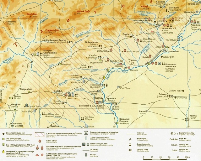
The Hierothesion at Mount Nemrut, constructed during the reign of the Commagene King Antiochos I (69-36 BC), was surrounded in antiquity by Melitene (Malatya) to its northwest, Pötürge to the north, Arsameia of the Euphrates (today Gerger) to its east, Samosata (the capital of Commagene) to the south, Perre (Pirin Village of Adıyaman) and Arsemia of Kahta (today known as Old Castle) to the southwest.

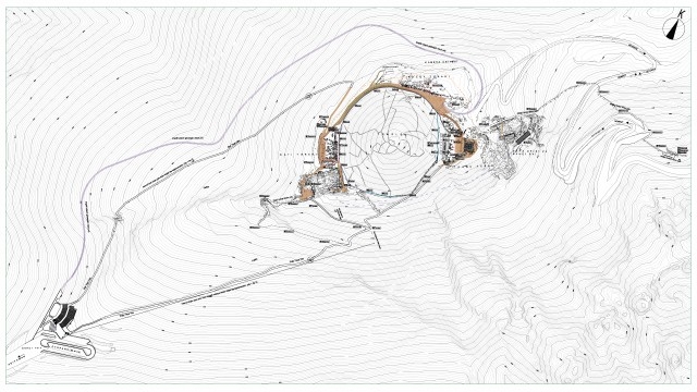
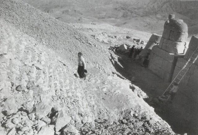
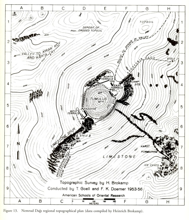
The area, approximately 2,6 ha, is composed of a conical tumulus with a 30-35 degree incline and three terraces to its east, west and north. The tumulus is 2206 m in height and 145 m in diameter. In ancient times, this area was accessed by two Sacred Processional Ways from the northeast and southwest, and another road to the north reaching a water source. These roads, identified by Goell with the help of inscribed stelae, can still be observed.


Terraces
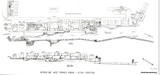
While the east and west terraces were organized in a similar manner, the north terrace differs completely. The level of the east terrace is 11 m higher than the west terrace. At the east terrace, which appears to have been organized symmetrically, on either side of the giant statues resting against the tumulus, are stone plinths with stelae on top as well as the altar which was defined by Goell as a stepped pyramid.
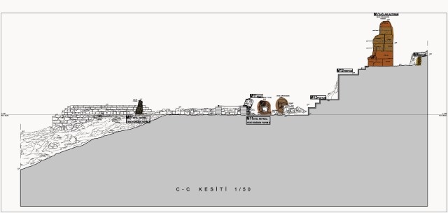
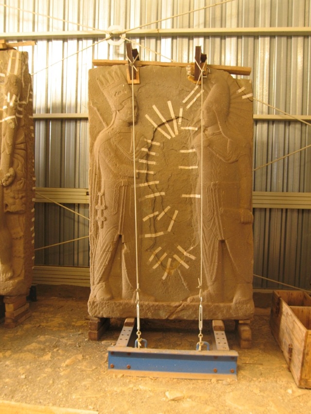
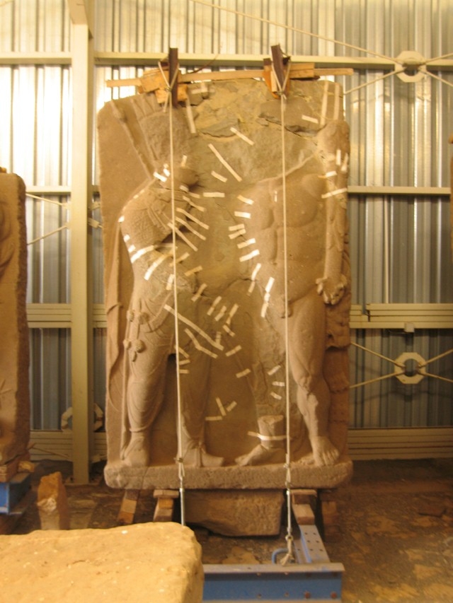
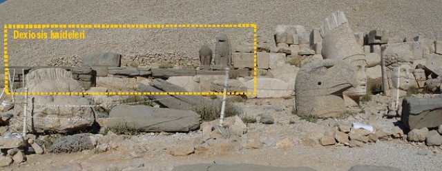
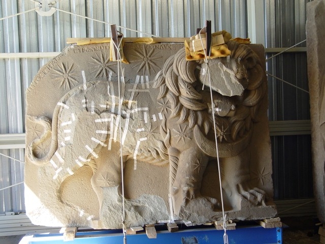
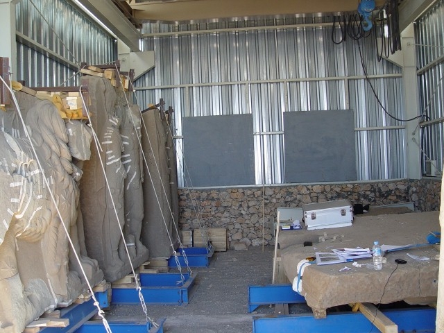
At the foot of the narrower and asymmetrical west terrace, which was widened at its west side with a retaining wall, there are colossal sculptures flanked by stele plinths with altars at the south and west sides. There are four dexiosis (handshake) stelae and a Lion Horoscope at the west terrace. These were transported to the Temporary Restoration Laboratory in 2003.
At the east and west terraces, there are limestone statues of King Antiochos with four gods, and a pair of protective lion and eagle sculptures at each side. These giant sculptures, situated on top of platforms at a higher level, create a monumental effect. The god sculptures are mentioned with their Greek and Persian names, in reference to Commagene’s unifying position between east and west.
In the form of a long, narrow rectangle, the north terrace houses a series of sandstone plinths and stelae without any reliefs or inscriptions. Among the two gaps in the series of bases, the one at the west was interpreted by Goell as an entrance gate to this area from the Sacred Processional Way.


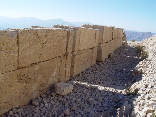

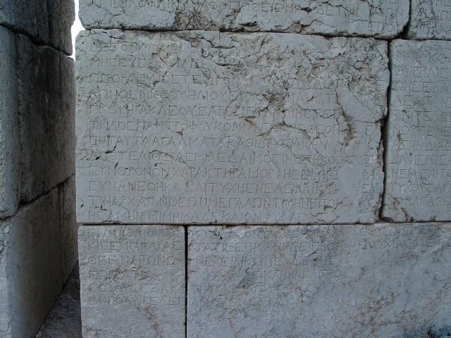
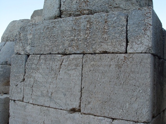
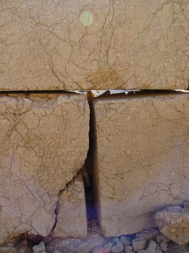
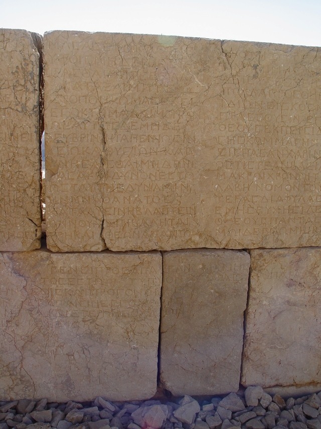
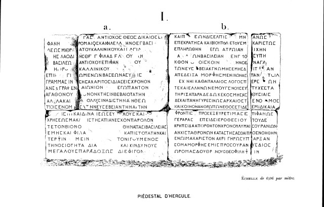
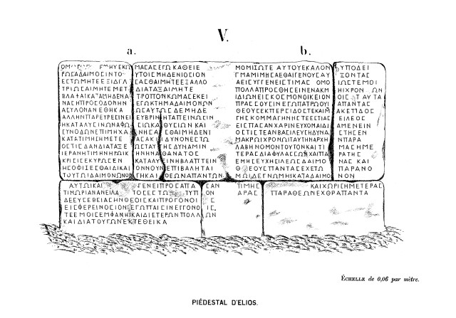
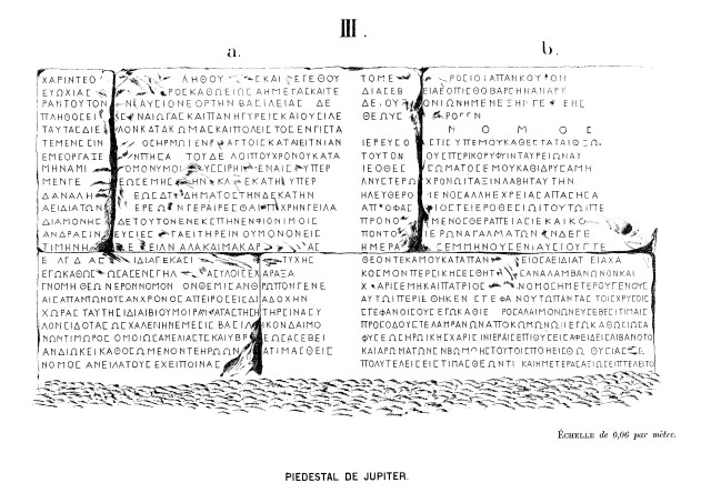
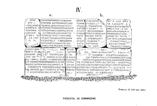
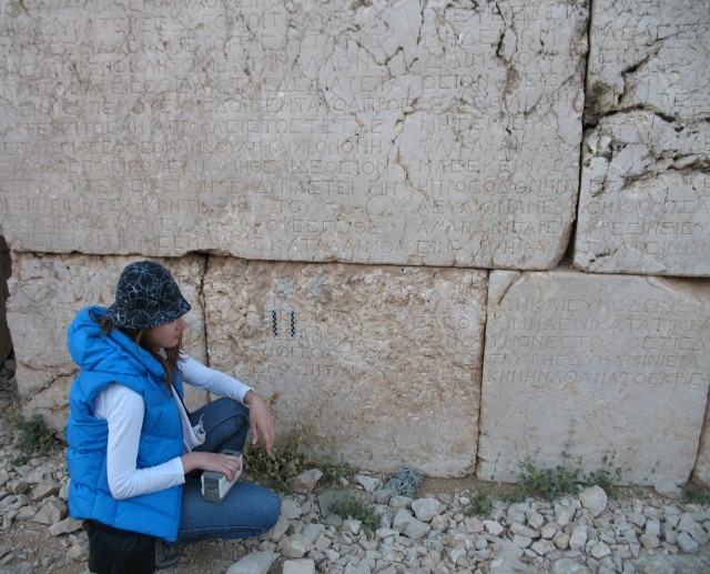
Nomos
Among the bases of gods’ sculptures at the east and west terraces of Tumulus is an inscription (nomos) with Antiochos’ testament carved with Greek letters. Aside from differences in spelling, both inscriptions are identical in content. The inscription, deciphered by Puchstein in 1882, was erected by Antiochos I (69-36 BC), who linked his lineage to Persian and Macedonian ancestors, so that
“His body, which remained in excellent condition until old age, to rest in peace after his spirit, loved by the gods, is sent to the throne of Zeus-Oromasdes in the sky”
Section IV, Line 205
“WHOEVER SHALL PRESUME TO RESCIND OR TO INJURE OR GUILEFULLY TO MISINTERPRET THE JUST TENOR OF THIS REGULATION OR THE HEROIC HONORS WHICH AN IMMORTAL JUDGEMENT HAS SANCTIONED, HIM THE WRATH OF THE DAEMONS AND OF ALL THE GODS SHALL PURSUE, BOTH HIMSELF AND HIS DESCENDANTS, IRRECONCILABLY, WITH EVERY KIND OF PUNISHMENT”


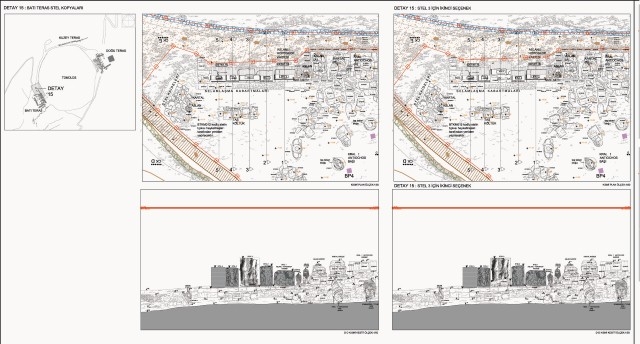
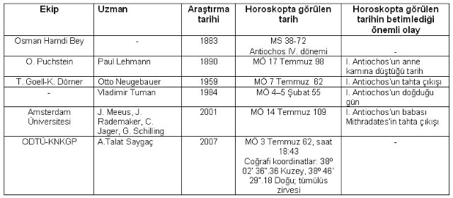
Lion Horoscope
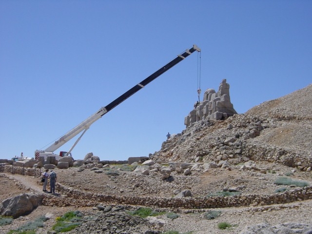
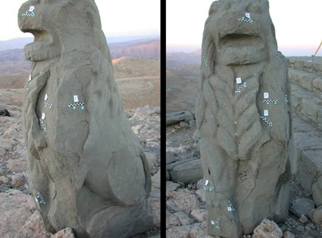
At the west terrace of the Nemrut Tumulus, a Lion Horoscope was found among sandstone stelae depicting scenes of King Antiochos I shaking hands with the gods (dexiosis). Unnoticed during Puchstein’s visit to Nemrut in 1881, these were discovered by Osman Hamdi Bey in 1882 during his excavations. For many years they remained as found until Dörner placed them at the west terrace in 1984 after reparing them with concrete and epoxy (Sanders, 1996: 163). Deteriorated in time, the stelae were transported to the Temporary Restoration Laboratory in 2003.

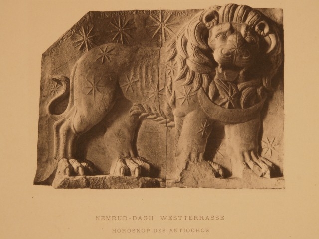

Dating works on the Lion Horoscope
The Lion Horoscope, approximately 1.75 m high and 2.40 m wide, is the earliest known Greek horoscope thus far discovered. The Lion’s body is depicted from the right side and its face from the front. There are 19 stars carved on its body and surrounding areas as well as a crescent at its neck. The names of Mars, Mercury and Jupiter are inscribed in Greek letters above the larger three stars on the back of the lion.
After its discovery, the monument attracted the attention of many researchers due to its historical characteristics and originality. They usually linked the date on the horoscope with the exact date for the construction of the tumulus. Hypotheses concerning the date depicted on the Horoscope are given on the table below.

Aim and Scope
The aim of the Preliminary Environmental Design Project (PEDP) is to prevent the deterioration of sculptures caused by uncontrolled mass tourism, to establish decisions concerning the conservation of monuments (without any physical intervention) and ensure controlled presentation and regular monitoring of the area until conservation and restoration works are defined, and to define a Management Model for their implementation. Besides preliminary architectural drawings of Visitor Centers at Adıyaman and Malatya entrances of Nemrut, 1/5.000-1/10.000 scale development plans were produced.
The environmental design project is completed in two stages as Preliminary Environmetal Design Project (PEDP) and Environmental Design Implemetation Project (EDIP). The PEDP was approved by Şanlıurfa Conservation Council in January 2008 and the EDIP is approved in December 2009.
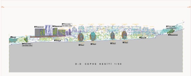
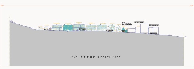
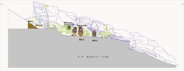
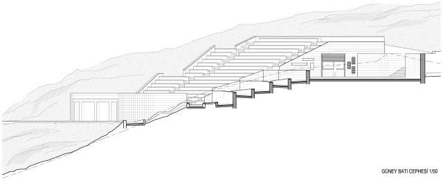
Environmental Design Implementation Project consists of the architectural drawings with various scales from 1/500 up to 1/50 of the festival area (former cafeteria), site office, guardians office buildings and the landscape elements and presentation of the site.
Methodology
The decisions made within the framework of the PEDP is based on the analysis of macro-scale plans in order to evaluate national and international legal requirements concerning the site; the assessment of the present condition of Nemrut; and the defined problems and potentials in the area.
Macro-Scale
Examined documents, the results of which were directly reflected upon the plans and projects, are as follows:
- Adana and Şanlıurfa Conservation Council and Ministerial Committee Decisions
- Southeast Anatolia Region Tourism Inventory and Tourism Development Plan (GAP-TETGP, 1999?)
- Mount Nemrut National Park Long-Term Development Plan (NDMP UDGP, 2002)
- Integrated Strategic Action Plan (ESEP, 2005) prepared within the context of the Southeast Anatolia Cultural Heritage Conservation and Tourism Development Plan (2005-2015)
- NEMRUT/ UNESCO WHS Periodic Reporting (2006)
Natural Environment and Roads
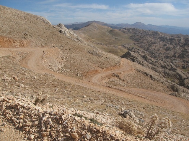
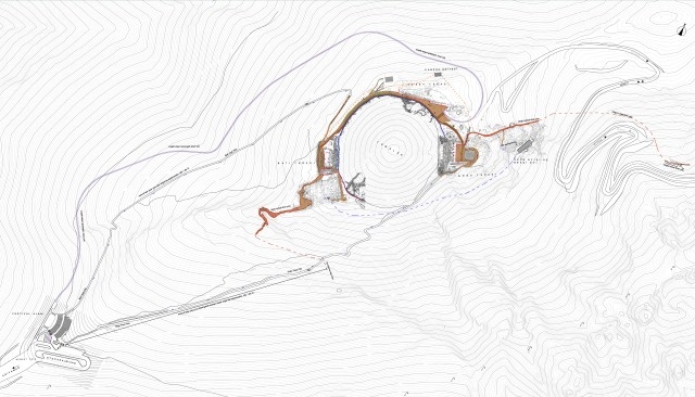
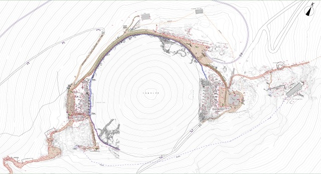
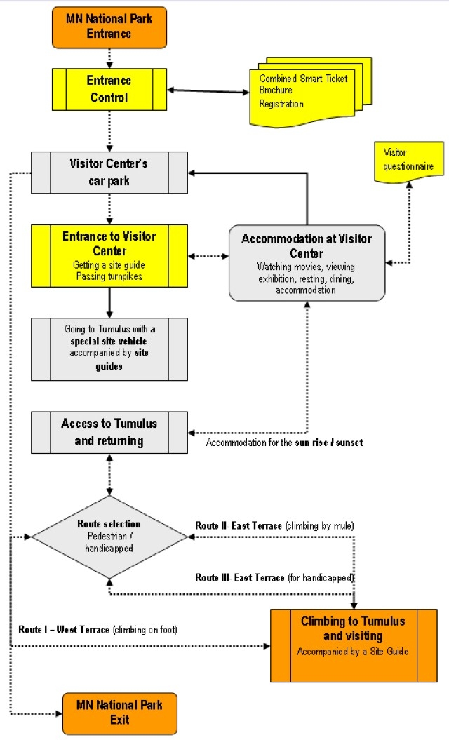
In order to preserve the natural environment of the Tumulus of Mount Nemrut and its values, it is planned to protect the site’s present natural characteristics. The roads connected to the area are deemed adequate, however a gradual improvement in their standards is proposed. The Mount Nemrut National Park Long-Term Development Plan proposes controlled vehicle entry to the site from the visitor centers onward. The PEDP envisaged access to Nemrut through seven visitor routes that will be opened progressively and made decisions for the use of the Sacred Processional Ways as well as disabled access to the area.
In accordance with these design decisions, the East and West pedestrian roads are kept but are arranged to join the Festival Amphitheater. The West Pedestrian Road follows the existing itinerary whereas the East Pedestrian Road is oriented towards the West Processional Way of the antique period. Both roads will be covered by gravels. In long term the two processional ways are planned to become the main approaches to the tumulus. The west approach from the Malatya direction is planned to follow the original itinerary of the East Processional Way, and the approach from Adiyaman will follow the original itinerary of the West Processional Way.
In the PEPD, a seperate itinerary and a special vehicule is designed for the disabled access. The itinerary starts from the west side of the festival amphitheater, continues towards north, goes around the Tumulus on the west side and reaches the East Terrace from the north. The road proceeds up to the Tumulus with a maximum grade of 15% following the topography. The vehicule is designed to carry the disabled person and two companions. Being pulled by mules, the vehicle rolls on rails. The arrival point of the vehicule is the wooden platform constructed between the North and East Terraces. The disabled go around the Tumulus on their own afterwards. The wooden platform continues all along the pedestrian access connecting the terraces. In order to adjust the existing road to allow access to the disabled, it is leveled by infill of compacted gravel. The platform is fixed on a steel frame placed on stone gravel infill. The platform is adjacent to the 50 cm high dry-stone wall holding up the Tumulus gravel.
Uses and Users
Four user groups were defined:
1. Visitors
2. Security guards
3. Personnel and researchers present or planning to work at the site
4. Artists and visitors participating in the festival
Considering the uses and users in the area, spatial problems were determined concerning safety, presentation, as well as basic requirements such as resting, dwelling, eating-drinking, WC. New building / spatial arrangements to meet these requirements were made within the scope of PEDP.
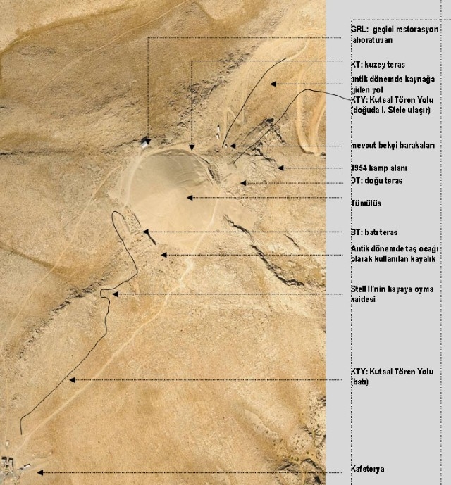
Existing Buildings
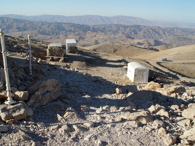
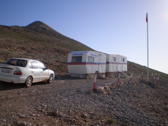
Aside from the archaeological elements at the site, man-made temporary structures (restoration laboratory, caravans, etc.), reinforced concrete or stone masonry permanent structures (cafeteria, water depot, etc.), building remains (sheepfolds, toilets, etc.) and building traces (construction foundations) were evaluated based on their effect on the visual unity of the site and their function, quality and location, upon which it was decided to remove them in phases. The cafeteria, which is located at the south and observed from the tumulus, will be demolished after the construction of the Visitor Center, to be replaced by a car park and a festival area.
New Buildings to be constructed
The construction of certain new buildings at the site and its near environs is planned in order to properly present the site to visitors, provide a contemporary shelter for the guards and a suitable environment for research groups who will be working at the site. The following buildings will be constructed:
– Two Visitor Centers (one at the Adıyaman entrance, the other at the Malatya entrance), and visitors’ toilets.
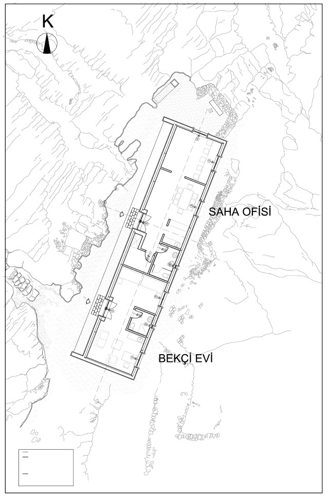
– A guard house for the guards who will be on duty at the site for long periods, and a field office for research groups (to be constructed at a location near the tumulus, but not visible from its surroundings)
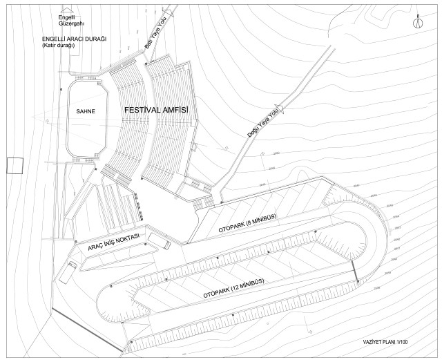
– An open-air theatre for the local festival to be constructed on the damaged topography that will be revealed following the destruction of the existing cafeteria building.
A site office for the excavation and research team, storage area, and a space for the security guards will be constructed at the east of the East Terrace, at a lower and hidden part where the remains of sheepfolds take place. The access to the building is by a stone stairway built on the natural topography. The façades of the one storey building will be cladded by local natural stone.
All the temporary buildings in the area (the restoration laboratory, caravans), the concrete or stone buildings (cafeteria, water storage), building remains (sheepfolds, toilet) and traces of the buildings (foundation remains) are planned to be removed gradually over time. The cafeteria building to the south of the Tumulus will be removed after the completion of the Visitor Houses and a festival area will be built in its place.
The Festival Area which will be the last vehicule access point at Mount Nemrut is planned to be an open air amphitheater with a car parking area made of two levels. The festival area is planned to host the annual Nemrut Festival, the beginning of the pedestrian roads and the disabled road start from this area.
An amphitheater, with a seating capacity of approximately 1000 people to host the Annual Nemrut Festival, will be constructed on the land where the existing cafeteria stands today.
Under the scene, located at the west part of the amphitheater, a backstage and artist dressing room and the the storage area to shelter the disabled vehicules take place and at the same time a shaded area is obtained for the visitors waiting to climb to the Tumulus by mules or with the disabled vehicule.
Toilet cabins will be put into service for the visitors. The cabins will be made of high performance solid acrylic material and will be located at the points invisible from the main circulation roads around the tumulus.
Presentation and Landscape Elements
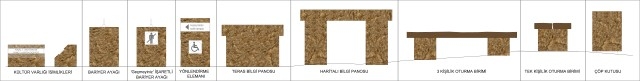
Certain landscape elements (benches, chain barriers, waste bins, and information/preventive panels) exist at the site in response to present needs. However, these elements are mostly of low quality and inadequate in number. The types, location and general aspects of landscape elements necessary for the presentation of the tumulus in accordance with contemporary criteria and security at the site were therefore determined within the context of the PEDP. The project proposed the placement of information/circulation/ presentation/preventive, etc. panels, waste bins, benches, barriers, circulation platforms, viewing points/binoculars, security cameras, etc. and new landscape elements which do not harm the integrity of the site, constructed of stone or embedded within stone, at levels which do not hinder the perception of the archaeological elements at the site.
Infrastructure Elements
There is no water or electricity at the near environs of the tumulus. Although it is not planned to illuminate the tumulus, water and electricity will be supplied without harming the landscape in order to ensure security and control at the site, to respond to visitor needs and to facilitate future conservation work at the site.
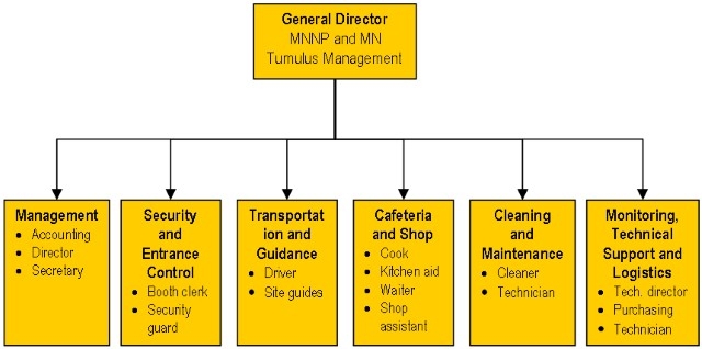
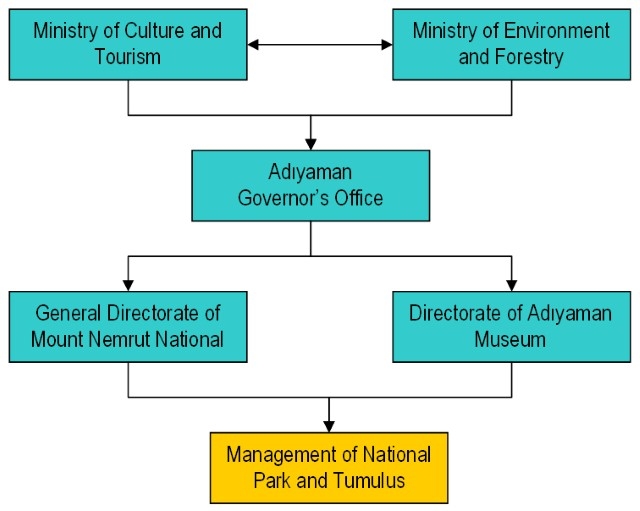
Administration, Security and Surveillance
The Adıyaman Museum, responsible for the archaeological site, has ensured security at the site by assigning four guards working in shifts during the season. It is difficult for the guards, who operate in pairs, to provide security in the area. Thus, the site will not be entered without the company of Site Guides. This way, local people will be educated as Site Guides and employment opportunities will be created.
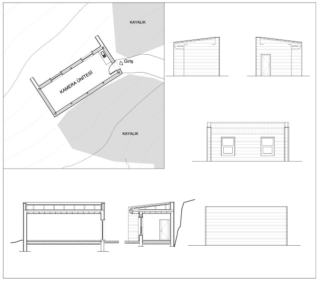
In order to provide security, a camera surveillance system, with 360° vision angle which are installed suitable to observe the whole terrace and the roads will be installed. The image will be transferred to the Camera Unit which is located at a point unseen from the tumulus, a single space building cladded with local stone.
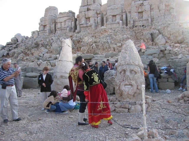
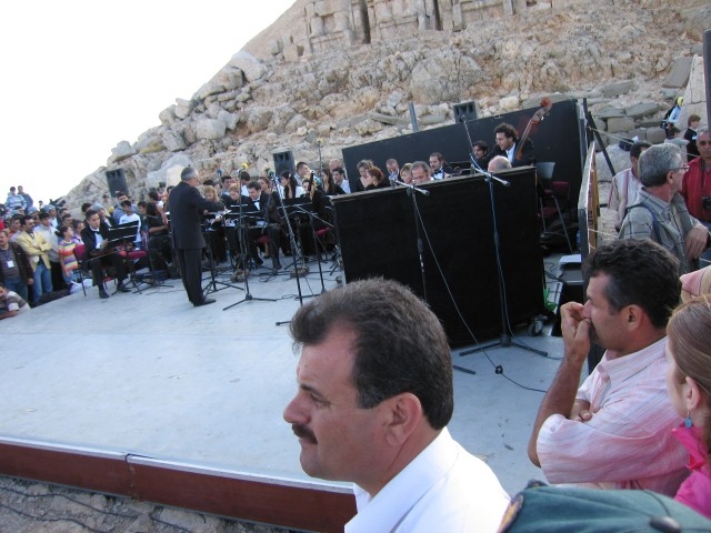
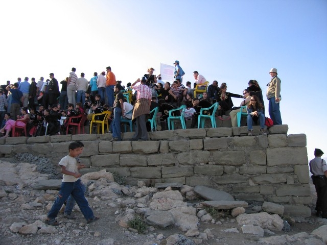
Figure 1 Methodology used in Mount Nemrut Tumulus Environmental Design Project
Figure 2 The use of area during the Nemrut Festival in 2006, METU-CNCDP, 2006
Figure 3 The use of area during the Nemrut Festival in 2006, METU-CNCDP, 2006
Figure 4 The use of area during the Nemrut Festival in 2006, METU-CNCDP, 2006
Figure 5 The use of area during the Nemrut Festival in 2006, METU-CNCDP, 2006
Figure 6 The use of area during the Nemrut Festival in 2006, METU-CNCDP, 2006
Figure 7 The use of area during the Nemrut Festival in 2006, METU-CNCDP, 2006
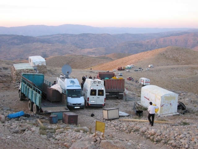
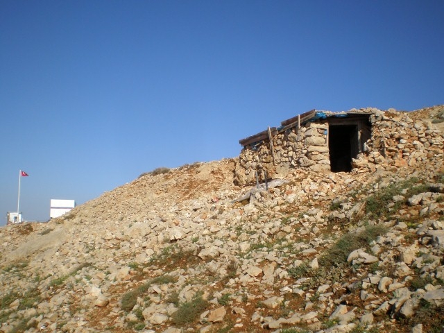
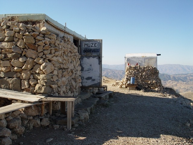
Figure 8 Guardian caravans located in the archeological area, METU-CNCDP, 2006.
Figure 9 Gendarme caravans located in the open auto-park area, METU-CNCDP, 2006.
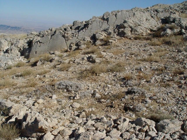
Figure 10 Remains of toilet building located on the eastern sacred way, METU-CNCDP, 2006.
Figure 11 The hut located in the south-east side of Tumulus, METU-CNCDP, 2006.
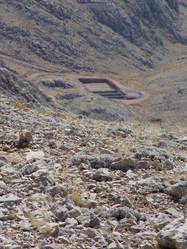
Figure 12 The foundation pit, which is percieved from a long distance, is located in the Photo -west direction of tumulus, METU-CNCDP, 2006.
Figure 13 Personnel shelters and water depot (Y6) METU-CNCDP, 2006.
Figure 14 Existing cafeteria, METU-CNCDP, 2006.
Figure 15 a-b-c
Figure 16 Mount Nemrut Tumulus Environmental Design Project
Figure 17 Mount Nemrut Tumulus Environmental Design Project
Figure 18 The festival area and car parking at the south of the Tumulus (the former cafeteria area)
Figure 19 Festival area – section
Figure 20 Lanscape elements at the Tumulus
Figure 21 Site office and guardians office
Figure 22 Security camera unit


In accordance with the Mount Nemrut National Park Long-Term Development Plan, two Visitor Centers were envisioned within the context of the PEDP; one at the Adıyaman side and the other at the Malatya side. The development plans, preliminary architectural projects and application the visitor centers were prepared. As most of the tourists arrive from the Adıyaman direction, the building at that side has a more comprehensive design.
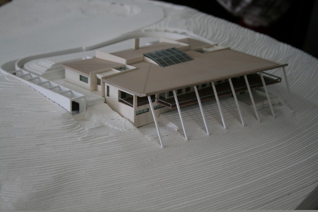
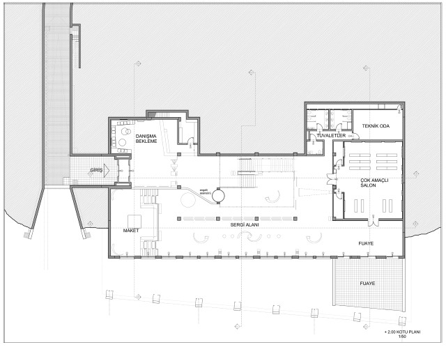
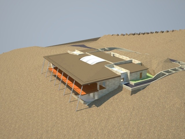
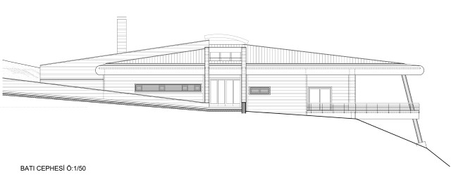
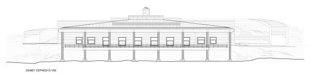
ADIYAMAN VISITOR CENTER
The Adıyaman Visitor Center will be constructed 2 km south of the Tumulus, at the nearest invisible area from the tumulus at a topographically suitable site. The building will be the last point for vehicular access with a car park for the visitors.
The objects of the design are to answer the needs and expectations of the different visitor groups (tourist, handicapped, student, etc.) and to offer open and closed spaces enabling alternative activities. The center will provide the visitors with contemporary presentation tools through which they will be informed about Nemrut, and their other needs will be taken care of. Besides its functionality, the building was designed with a concept which integrates the spatial continuity, circulation, light and conception of the environment.
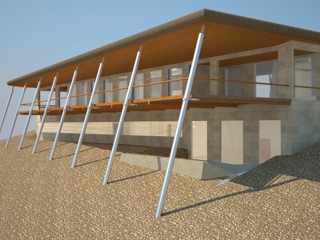
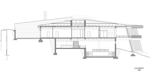
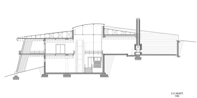
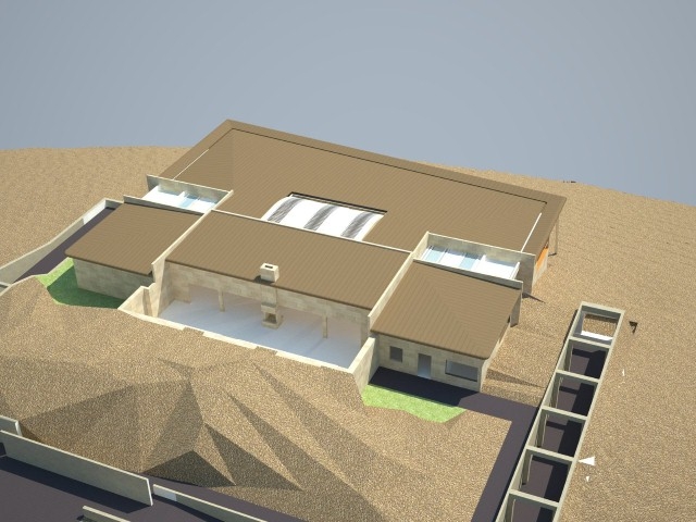
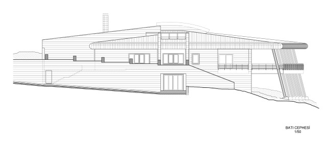
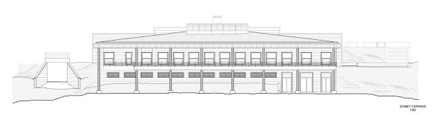
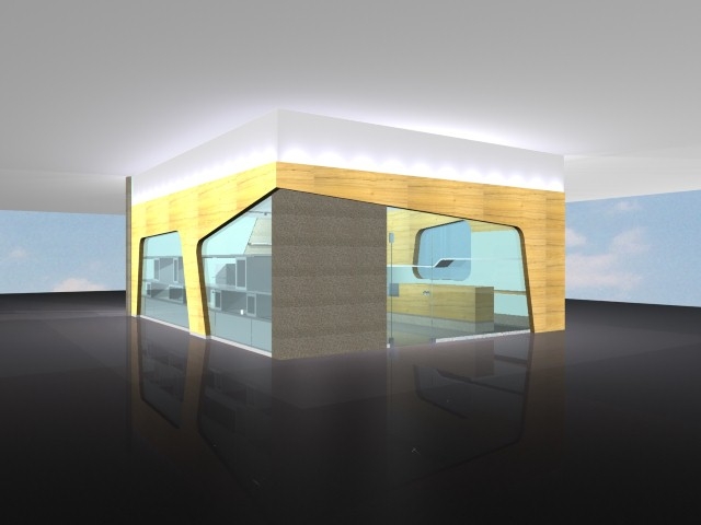
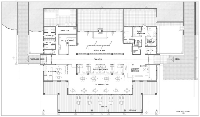
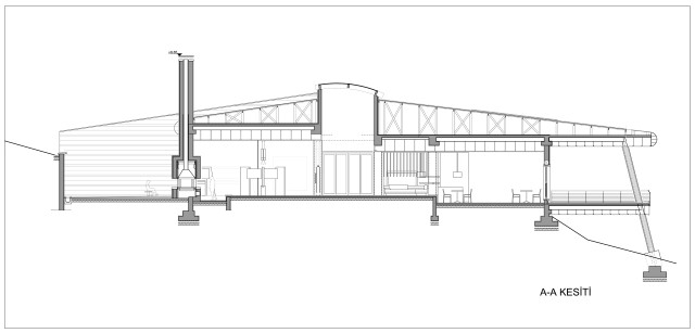
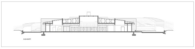
The two storey Adıyaman Visitor Center is oriented towards south facing the landscape with a spatial organization providing visual continuity between floors. The building is hidden in the landsape, difficult to be perceived from the road and the car park. The natural topography between the building and the main road is conserved and tunnel formed entry- exit corridors are designed for the access.
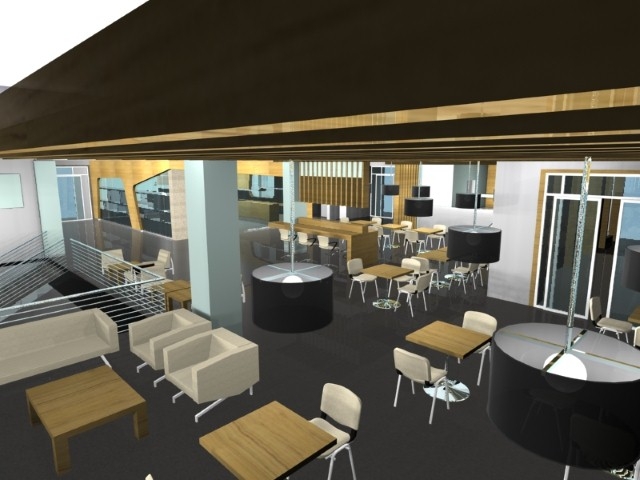
A wooden terrace goes all along the southern façade of the building looking down the landscape. The wooden terrace enlarges towards the east end with an angle coherent with the topography and the roof fringe proceeds to cover the terrace. The cylindrical steel columns carry the terrace and the superstructure. To the north an inner courtyard is created in between the slope of the landscape and the building. All façade openings of the building are designed to be totally closed when the structure remains inactive in winter season in order to be protected from the harsh climatic conditions. The façades are cladded with large size rough stones.
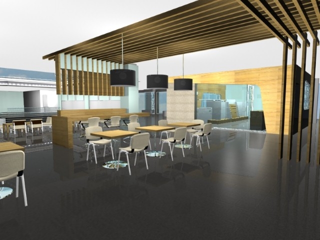
The main circulation axis is between the entry-exit points on the east and west ends of the building. The exhibition spaces, rest areas, multi-purpose room, sales units and cafeteria are placed at left and right sides of this main axis. The visitors enter the building fom the west entrance on the lower level, tour around the Nemrut exhibitions, pause and have rest and exit from the east end on the upper level in order to take the road to the Tumulus.
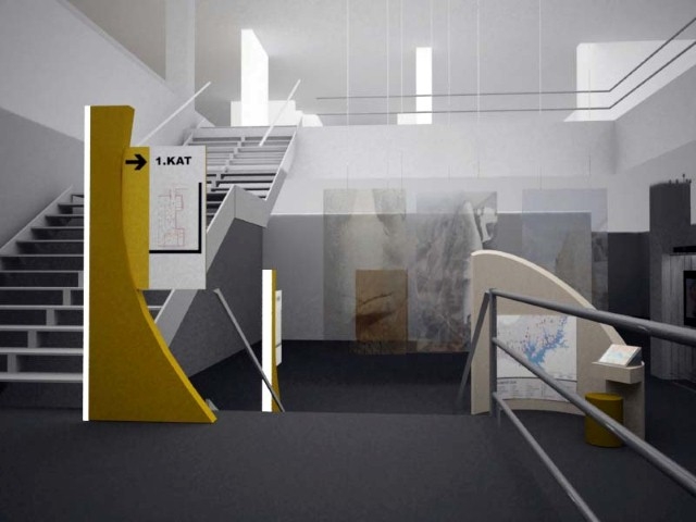
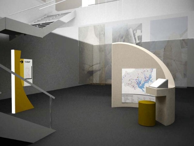
The galery gap in the middle of the building including the stairs and the handicapped elevator provides the spatial contunity between the exhibition spaces and rest areas in the upstairs. With the help of roof skylight in the galery projection, sunlight mostly reach to the downstairs in earth.
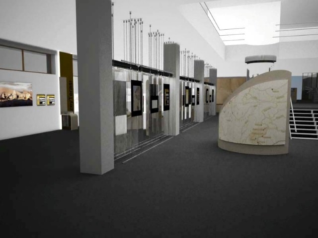
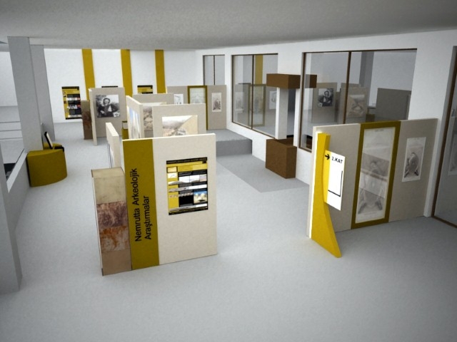
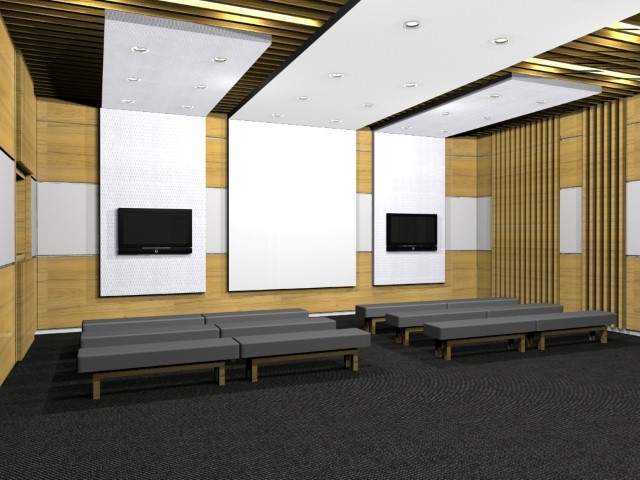
In the exhibition spaces, all of the values of Nemrut Dag Tumulus are aimed to be presented. After the visitors pass the entry hall and reception unit in downstairs, they are provided to follow the informations in the languages they prefer by headphoned devices.
The lower exhibition space has modules that have thematic issues on it and presented inscriptions about Commagene Kingdom. These themes are Nemrut Mount national Park, “Lion Horoscope” and astrological datings, model of site area, location and features of Tumulus, architectural features of structures, informations about the three terraces, regional geographical conditions and physical features. In order to diversify the graphical presentation and to gain 3D perception, some elements will be used such as site model, small replicas of statue heads that can be touched by visually handicapped people and copy of Lion Horoscope stelle in the presentation.
In the downstairs multi-purpose room, there are movie/DVD/video presentations in four different languages. The open-closed lounges of the room which will host various activities at different times look to the southern landscape.
The upper exhibition space is evaluated as one mass with the inner courtyard at the North and a large furnice that can be percepted both from inner space and outer space is placed to the center. King Antiochos’ Nomos is presented here as Turkish and English and original dimension replicas of Nomos are presented in stone masonry courtyard walls. The visitors encounter the inscription here for the first time. In the rest of the exhibitions, the story of Nemrut Dag Tumulus is explained from its discovered times.
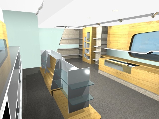
Next to the upper exhibition halls there is sale unit where the visitors can get souvenirs peciluar to vicinity. Rest areas, cafeteria and terrace are placed oriented to the landscape with an interrelating order. In those spaces where it is arranged that the visitors can rest and eat between the sunrise and sunset, they wait for re-climbing to the Tumulus.
MALATYA VISITOR CENTER
Malatya Visitor Center is positioned in the arrival direction of Malatya to Nemrut Dag Tumulus in order to inform and meet the needs of visitors. The building which is approximately in 2km northeast of Tumulus, is the last vehicle access point from Malatya. The building is a one storey structure that has the same architectural language and approach with Adıyaman Visitor Center that is about spatial speculation, circulation, façade organization, relationship with light and environment.
The application projects of visior centers were done by SAYKA İnşaat Mimarlık Müh. Müş. Tic. Ltd. Şti. The projects are approved by the Sanliurfa Cultural and Natural Assets Regional Preservation Council on 30 December 2009.


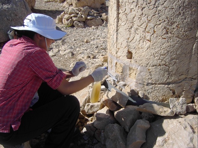
This research aims to ensure that consolidation work:- Forms a structure similar in composition to that of the existing stones,- is re-applicable,- Compatible and unified with the less deteriorated and sound original structure.
Researches done in the scope of the project include the following:
Scope
1. Analysis of stone deterioration: Determination of changes created in the stones’ physical, mechanical, mineralogical and chemical structure.
2. Definition of conservation interventions:
- Definition of consolidation methods and their testing on stones geologically similar to the monumental stones
- Development of compatible mortars for re-adhering and filling gaps,
- Evaluation of the conservation interventions to be applied with respect to their durability and compatibility.
3. Compatibility and durability testing of conservation interventions:
Experimental implementation tests on stones geologically similar to the monumental stones and in pilot areas selected on the monuments.
4. Definition of interventions and education of implementation team:
The definition of methods with respect to materials and implementation techniques based on experiments and in-situ tests, as well as on site work to be implemented in later stages.
Research
1. Analyses on the monument
- Mapping of deterioration types
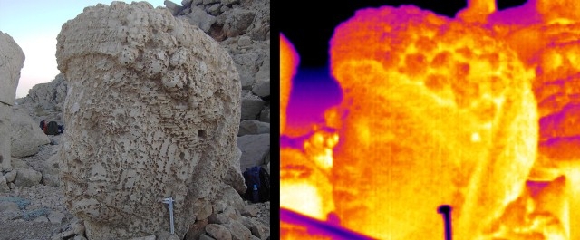
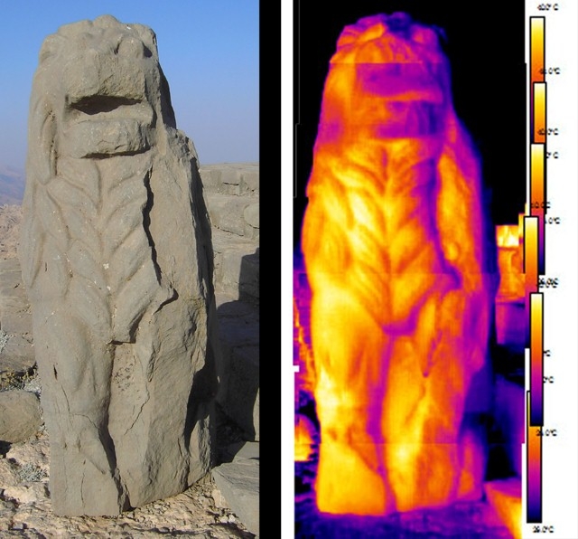
- Infrared image analysis
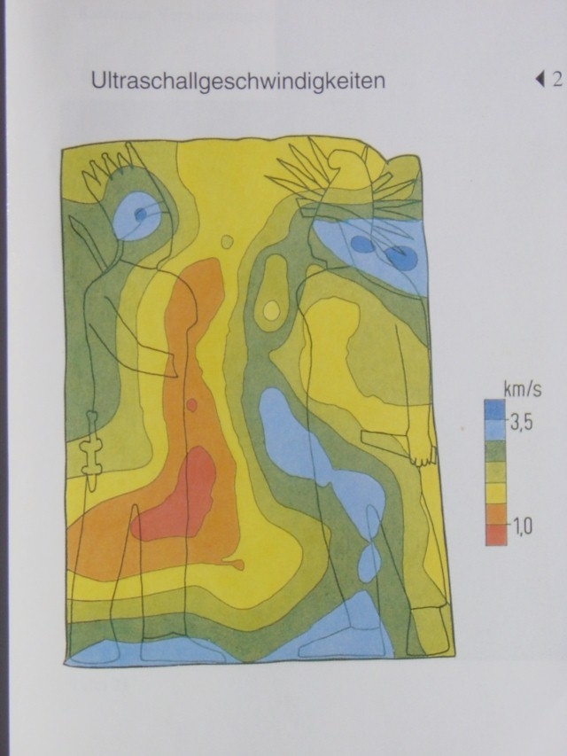
- Ultrasonic sound measurements
- Color measurements
2. Laboratory Analyses
- Determination of physico-mechanical characteristics
- Micro samples taken from the monument
- Optical microscopic analysis of thick and thin section
- SEM-EDX analysis of thick samples
- FTIR analyses
- XRD analyses
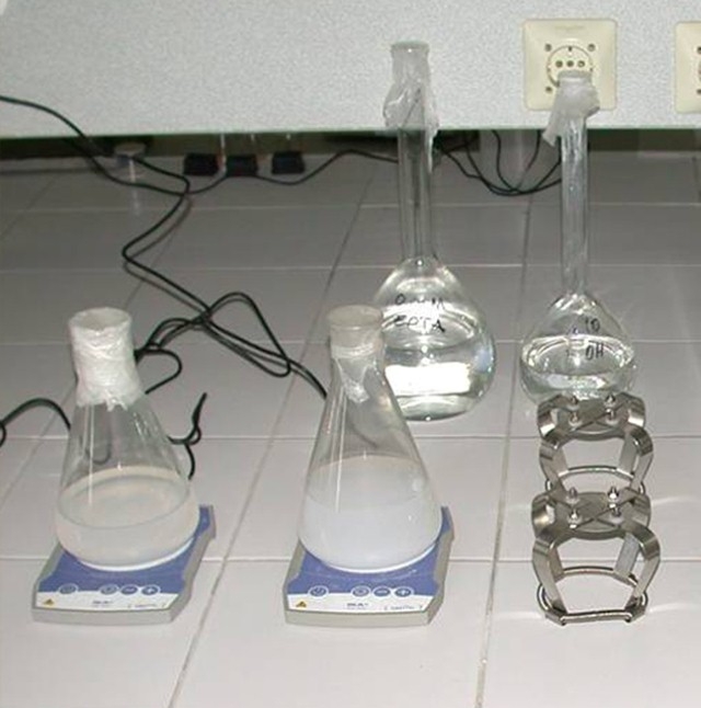
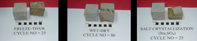
- Durability experiments: Salt crystallization, wetting-drying and freezing-thawing cycle tests of artificially decayed stones to determine/perform
- Physico-mechanical characteristics
- Analysis of micro-structural characteristics by SEM-EDX and thin section analyses
- Color analyses
- Dilation characteristics
- Research on Conservation Interventions:
- Control of biological deterioration
- Prevention of the formation and/or development of detachments, layering and indentation by reducing crack development
- Consolidation by the formation of minerals similar to existing stones’ structure
- Filling of fine cracks and capillaries
- Adhering, filling cracks and gaps with compatible mortars
Development of surface consolidation methods by biomineralization
Research Results
Laboratory and field works and research results include the following:
- Investigation with non-destructive analyses: Pre and post monitoring analyses of urgent and comprehensive intervention areas by non-destructive analyses
- Diagnosis studies of decay problems on limestone statues and their bases and the relevant conservation applications
- Diagnosis studies of decay problems on sandstone statues and steles and development of conservation methods
- Investigation of biological deterioration
- Preparation of pozzolanic mortar in order to stick the detached layers and to fill the large cracks and gaps
- Investigation of protective textile covers
As a result, the following proposals are developed:
- Stone Maintenance and Intervention Program (5 Year Program)
- Stone Maintenance and Intervention Descriptions, Team Definition and Education
- Main Principals of Stone Material Oriented Interventions
- Limestone oriented Interventions (ILIMESTONE)
- Sandstone oriented Interventions (ISANDSTONE)
- Stone Conservation Studies Research and Education Team
- Qualification of trainees and education program
- Mapping of the Intervention Descriptions at the site
- Definition of Monitoring activities and duration
Intermediate results about the studies have been reported and presented to the Ministry of Culture and Tourism in stages since December 2008. Material Investigation Final Report was finalized in August 2011 and was approved by Ministry of Culture and Tourism in October 2011.
The conservation-repair activities and the projects were developed according to the material investigation results.

Aim
The purpose of the geological study is to investigate the deterioration mechanisms of the stones and to provide data for the purpose of conservation of the statues.
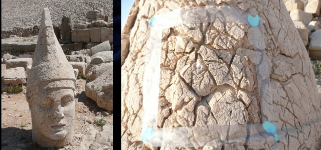
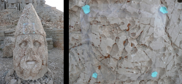
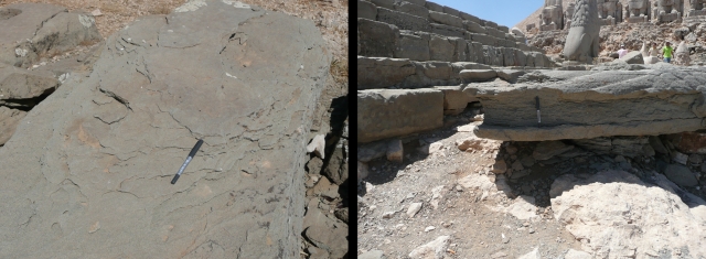
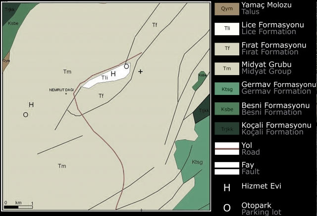
Rock Types
Statues: Limestone
Horoscope and Reliefs: Sandstone
Weathering Forms
- Widening of fractures in limestone due to dissolution
- Dissolution related pitting in limestone
- Spalling along bedding planes of sandstone
Field Studies
- Geological mapping
- Sampling from geological formations
- Investigation of weathering forms on natural outcrops
- Investigation of weathering forms on the statues
- Fracture analysis on statues with the help of photographs
- Crack and pitting analyses
- Detection of possible further material loss areas
Laboratory Studies
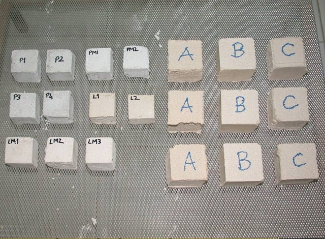
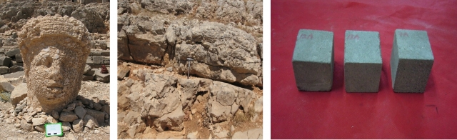
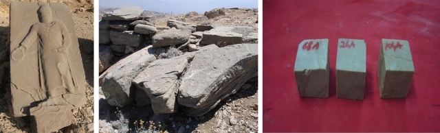
- Preparing 400 cube samples with dimensions of 5x5x5cm
- Determination of physico-mechanical properties of the samples
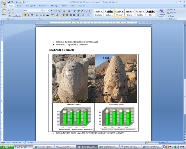
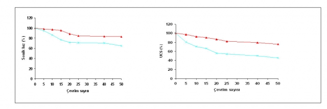
- Ageing testing on cube samples
- Ageing Testing: (Order of deterioration) Salt crystallization > Freeze-Thaw > Wet-Dry
- Mineralogical and petrographical investigations
- XRD, XRF and SEM analyses
Intermediate results about the studies have been reported and presented to Ministry of Culture and Tourism in stages since December 2008. Geological Investigation Final Report was finalized with the Material Investigation Final Report at August 2011 and was approved by Ministry of Culture and Tourism at October 2011.
Conservation-repair projects propositions were developed according to geological investigation results.


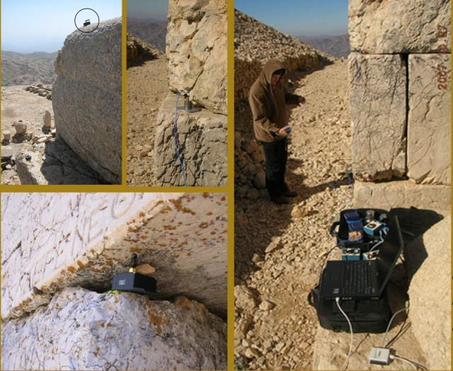
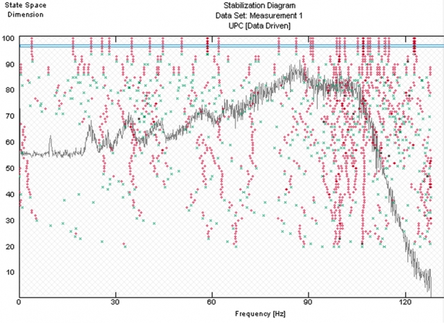
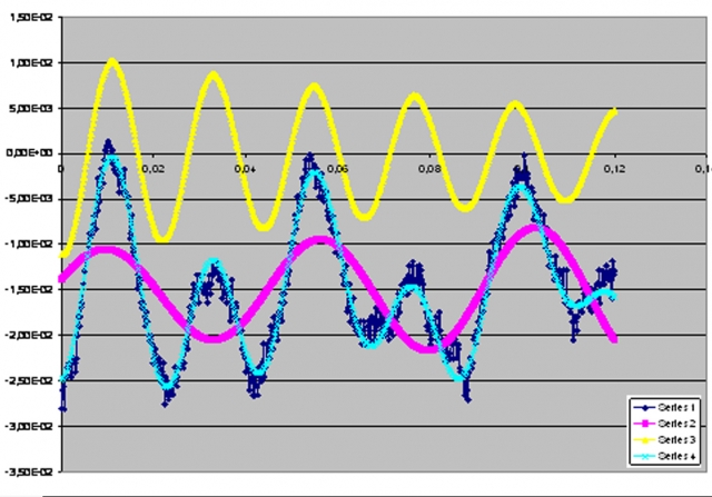
The structural investigations of Nemrut monuments aimed mainly to reverse-engineer collapses in the east and west terraces. Various monitoring, modeling, and testing studies carried out since November 2006 within this framework are listed below.
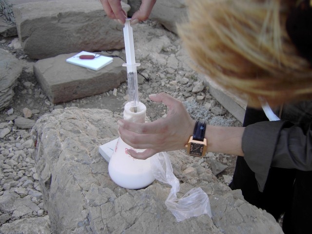
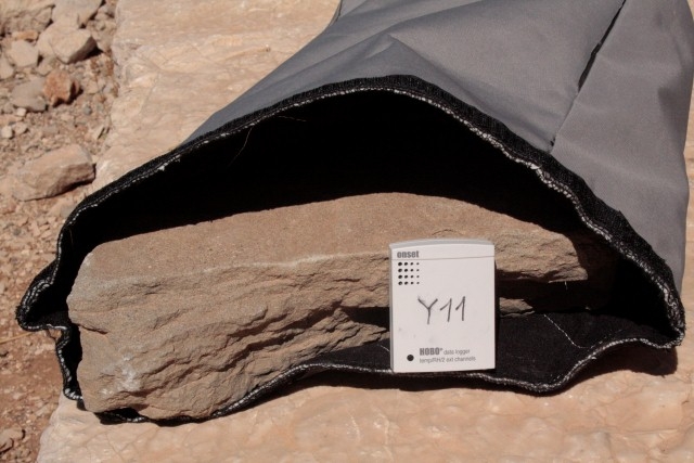
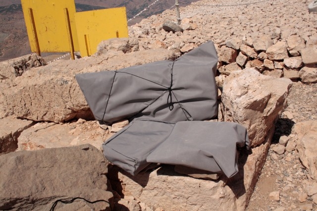
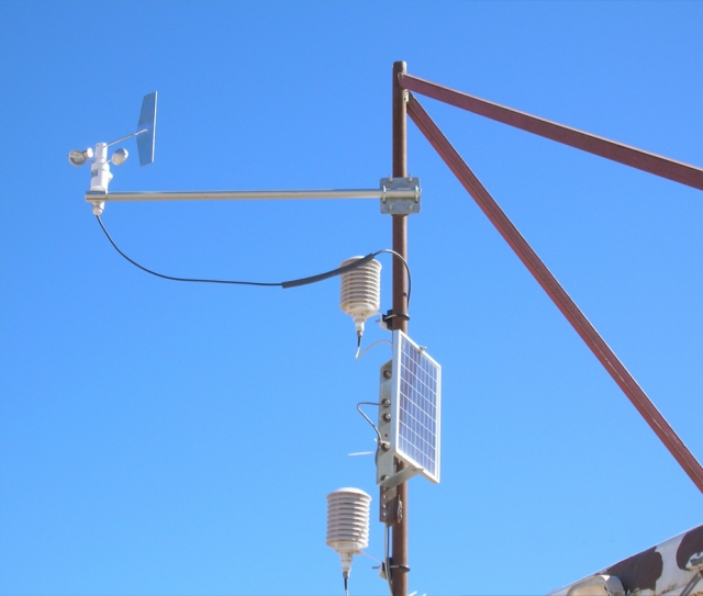
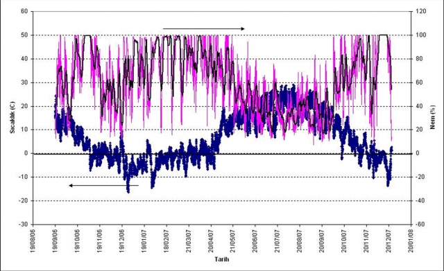
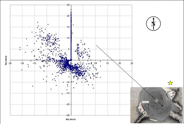
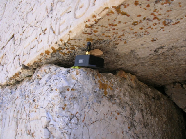
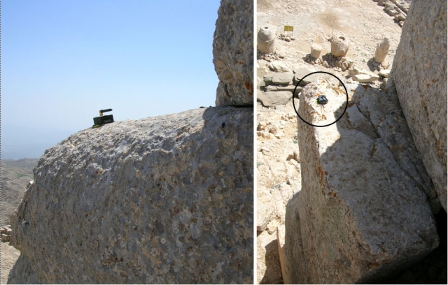
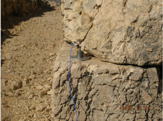
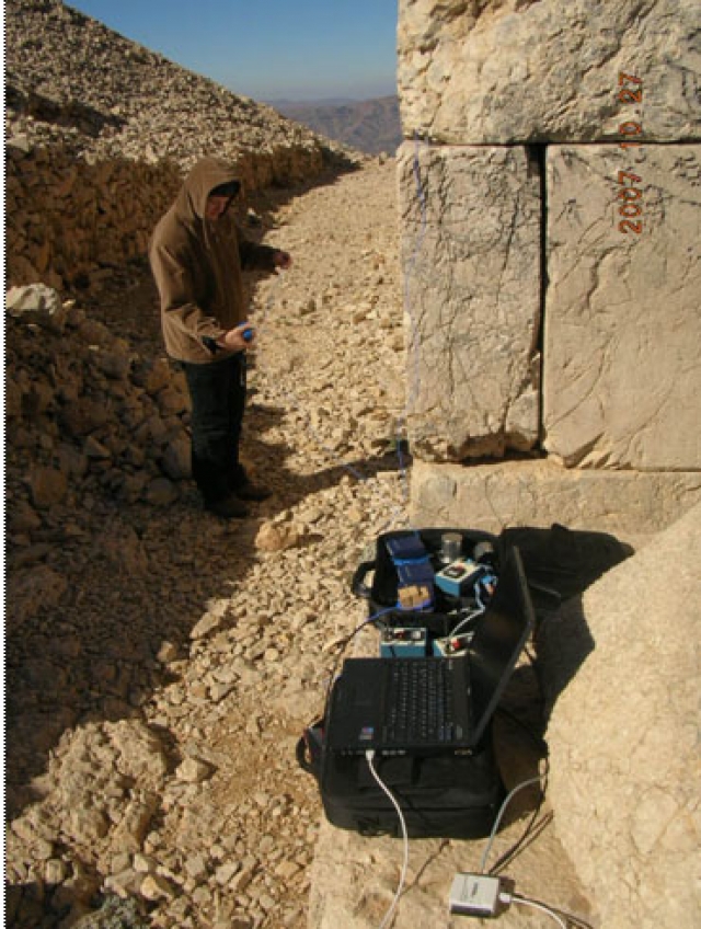
Climatic Data Analysis
Monitoring temperature, humidity, wind direction, and wind speed by means of a variety of sensors located on the site
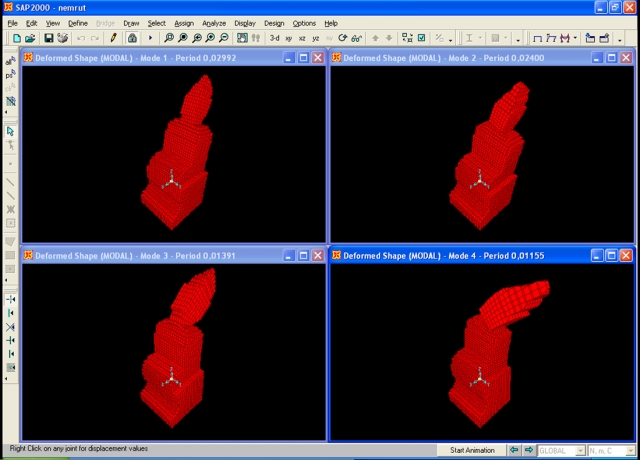
Analytical Modeling
Analytical modeling of the monuments using different tools and methods
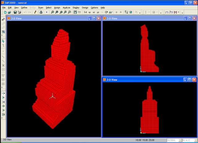
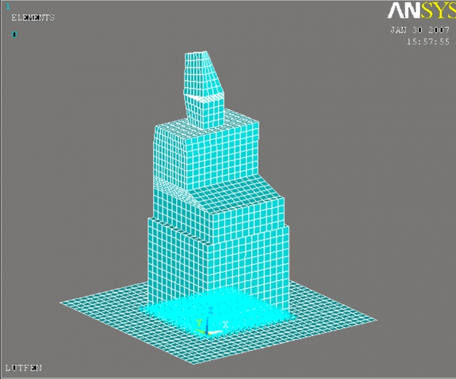
Earthquake Analysis
Recorded and synthetic earthquake analyses performed on these analytical models (17 January 1995 Kobe–Japan, 13 March 1992 Erzincan–Turkey, 17 August 1999 Gölcük–Turkey, 5 June 1999 Lucerne–Switzerland, and 12 November 1999 Düzce–Turkey)
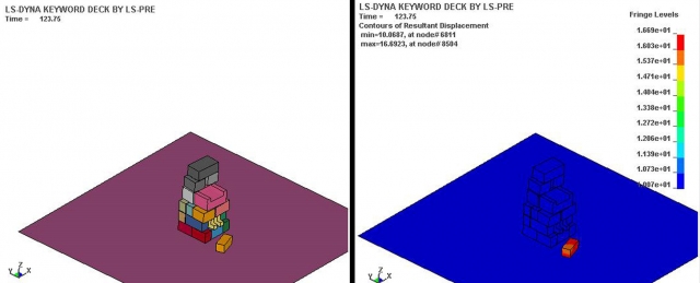
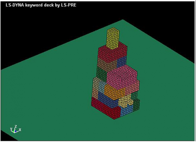
Blast Loading Analysis
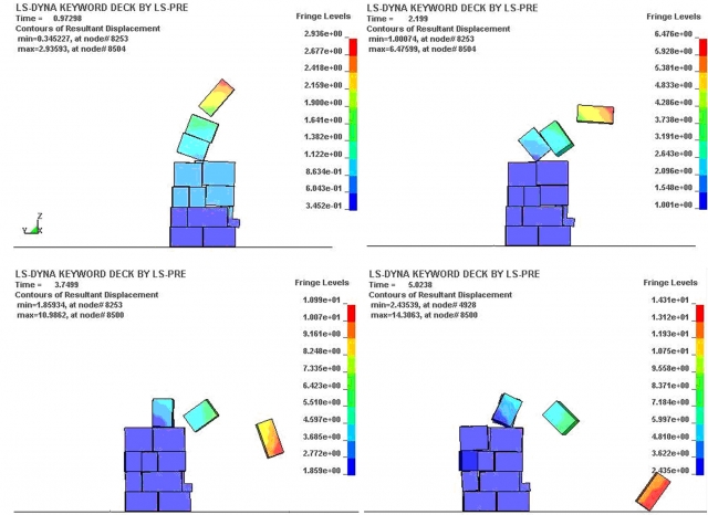
Blast loading analyses performed on these analytical models
Collapse of the monument at 0.97, 1, 3.8, and 5th seconds, respectively, in the case 2000 kg explosive is used
Dynamic Tests
Dynamic tests performed at two technical visits to the site
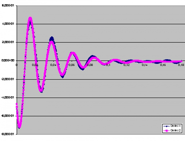
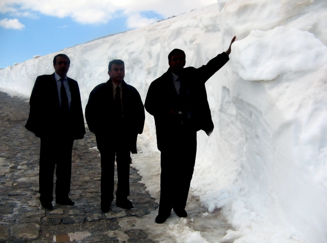
Snow Load Analysis
Calculation of probable snow load in the site

Conclusions
The following conclusions can be drawn at the end of the studies carried out so far and summarized above:
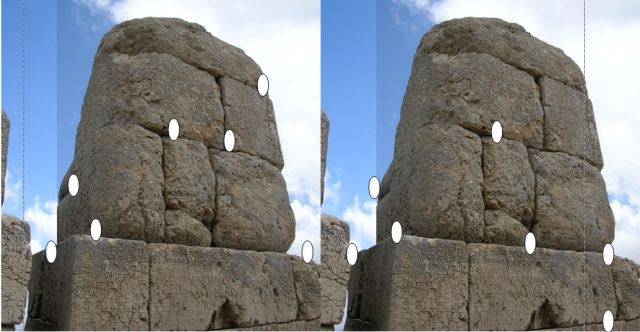
- Even though it is possible that the monuments collapsed as a result of repeated seismic activities, it is insufficient to say that the earthquake is the explanation of physical integrity difference between the monuments of the two terraces. The fact that in the east terrace all blocks were collapsed in the east direction whereas in the west terrace all blocks were collapsed in the west direction is incongruous with the demolition forms after earthquake.
- The computer simulations have shown that the monuments can also collapse as a result of blast loading. However, a reasonable relationship between the diameters of the craters at the tumulus and the amount of explosive used cannot be reached. In order to constitute the crater diameter with explosive tons of them are needed and it is not physically possible. Probably, craters were opened by hand or machine digging. Therefore it is thought that monuments did not collapse as a result of an explosion.
- The monuments could be destroyed under snow load. That possibility is important for the explanation of the difference between two terraces if the monitoring studies conclude that the dominant wind direction is from east to west. As the wind direction sensors could not be operated regularly because of the exterior conditions, the wind direction could not be determined exactly. However, the previous researchers’ observations and photographs which show the west terrace under extreme snow load; also the fact that the slope of the tumulus ending just at the behind of the monuments at the west terrace and the statue blocks collapsed all in the same direction and fell far from tumulus support the idea of snow caused destruction.
- As a consequence of analytical models and measurements on monuments, one single earthquake cannot destroy the monuments but it is evaluated that more than one earthquake could move the stones step by step and caused a collapse in hundreds years of time. It is estimated that the destruction in the west terrace is not because of the earthquake, due to the snow or foundation settlements unidirectional collapse was occurred.
Intermediate results about the studies have been reported and presented to Ministry of Culture and Tourism in phases since December 2008. The Structural Investigations Final Report was finalized with the Material Investigation Final Report in August 2011 and was approved by Ministry of Culture and Tourism inOctober 2011.
Conservation-repair activities and the projects were developed according to the structural investigation results.
Documentation work is to comprise the following:
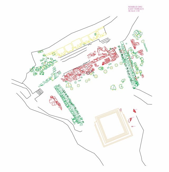
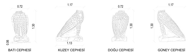
1. Measured Drawings: A total of 39 drawings in scales varying from 1:10 to 1:500 showing the current status of the Tumulus and its near vicinity,
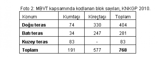
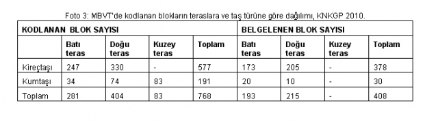
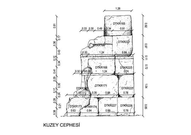
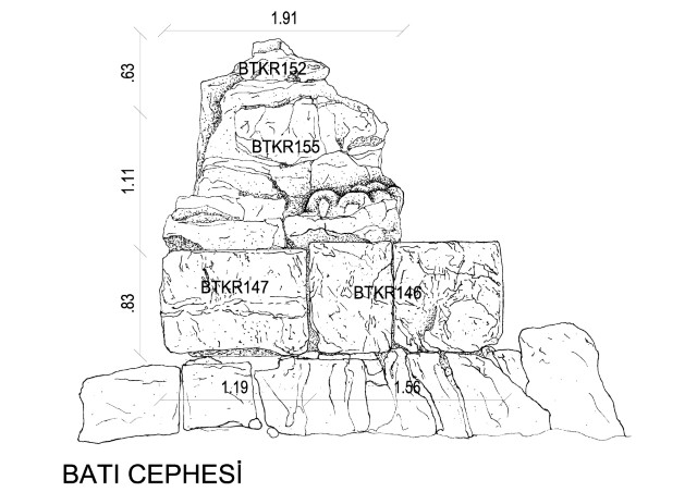
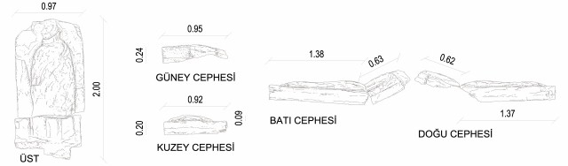
2. Architectural Blocks Documentation Work (ABDW): A total of 107 drawings, either in 1:10 or 1:20 scale, mapping the deterioration of 408 stone blocks in the area
3. Architectural Blocks Data Base (ABDB): A list of 768 stone blocks with 1:50 scale drawings and descriptions in Microsoft Excel,
4. Mount Nemrut Tumulus Documentation Report: A report of the historical background and architectural properties of the site, including information gathered from all previous researches, as well as a definition of the problems of the site.
Measured Drawings:
The drawings were completed after the completion of the site works in the summer seasons of 2006 and 2008. The drawings were controlled at site and final revisions were made during the 2009 summer work period. All drawings were completed and submitted to the Ministry of Culture and Tourism in October 2010.
There are a total of 39 measured drawings of the Tumulus and surrounding areas.
1:500 scaled measured drawings
The 1/500 scaled plans, comprising two sheets, cover the Tumulus itself, the three terraces and the surrounding areas, including the cafeteria.
1:200 scaled measured drawings
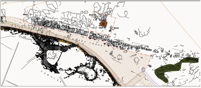
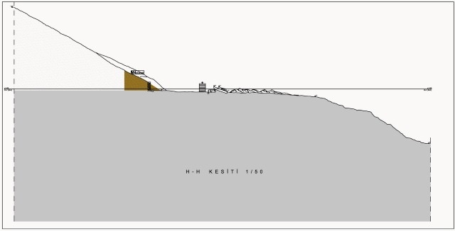
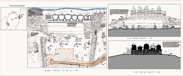
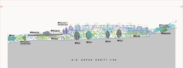
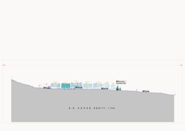
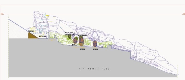
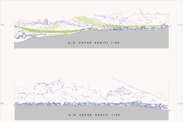
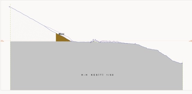
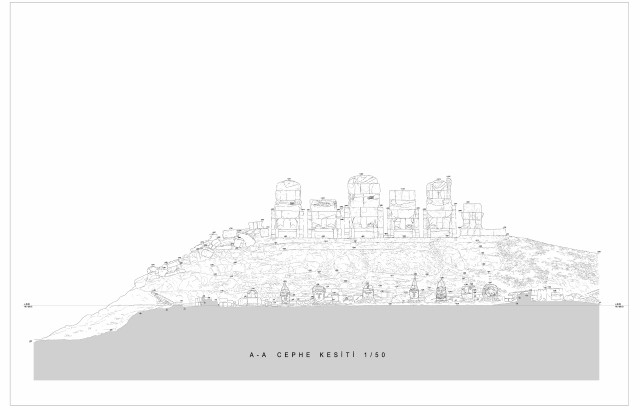
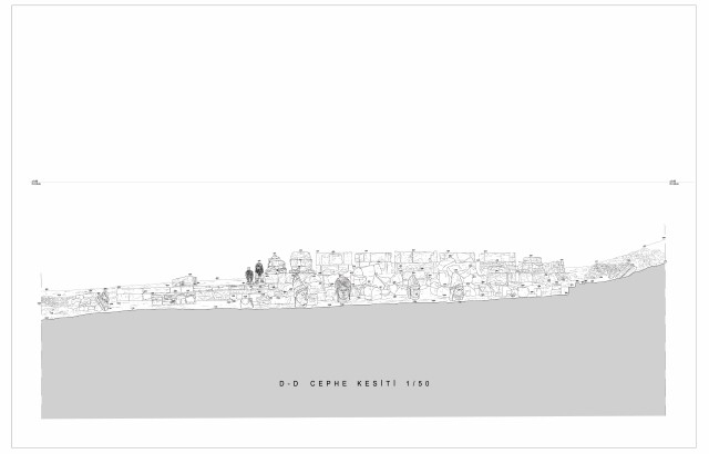
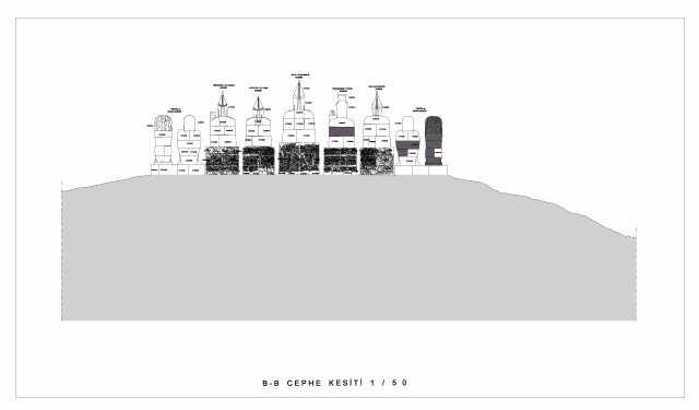
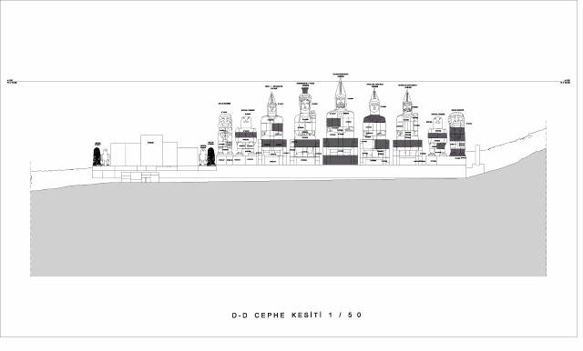
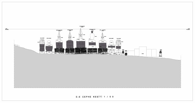
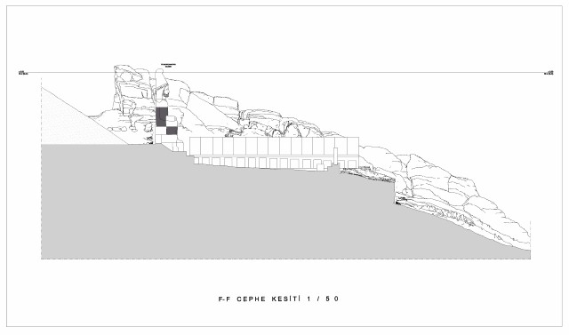
Nine of the 13 1:200 scaled drawings are plans, while the rest are sections and elevations. Plans A, B and C together cover the cafeteria to the south and the adjacent car park; the Mount Nemrut Tumulus at the center; the Sacred Processional Way to the east; and the North Terrace and Malatya road to the north (Figure 1a). The two section/elevations and the two 1:200 scale sections of the Tumulus along the east-west and north-south axes show the Tumulus, the Terraces and surrounding areas in three dimensions.
1:50 scaled measured drawings
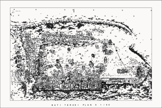
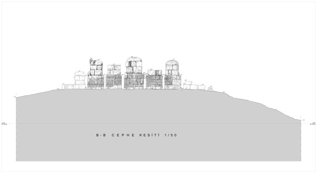
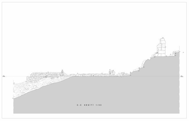
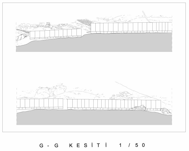
The 1:50 scaled drawings comprise 16 plans and eight section-elevation drawings covering the East, West and North Terraces and the Tumulus
Methodology of Documentation:
The measured drawings were prepared during the site studies of 15 September–03 October, 2006 and 10 October–20 October, 2008. The measurements were taken using optical/electronic devices over the course of 30 days by a site team comprising five specialists.
The measurements were connected to the polygons of the national grid coordinate system on the 1:1000 and 1:5000 scale ortho-photo maps prepared in 2007, which cover an area of 2,584 hectares and include the environs of Mount Nemrut Tumulus and Kahta.
All drawings are sdcanned as image and transformed to digital form by the use of computer programs. In addition, the Tumulus and its surroundings were documented with 3,860 photographs.
Architectural Blocks Documentation Work (ABDW):
In addition to the documentation work explained above, some of the most important stone blocks were measured and drawn in 1:20 or 1:10 scales. . This work comprises the documentation of the visible façades of 402 stone blocks at the site. For 308 of these blocks, deterioration mappings of the visible sides were prepared.
Mount Nemrut Tumulus –Architectural Blocks Data Base (MNT-ABDB):
Over seven hundred stone blocks are studied in the site.
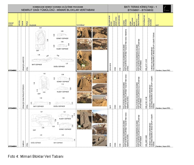
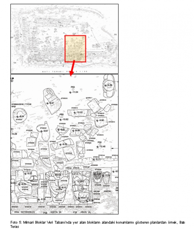
In addition to this, in order to help perceive the site as a whole and also to create a thorough inventory of the area, a database – the Mount Nemrut Tumulus Architectural Blocks Data Base (MNT-ABDB) – was prepared, identifying, defining and registering the stone blocks that are shown in the 1:50 scale plans. In this database, a total of 768 blocks that are fragments of the statues or/and stelae was defined using a coding system, and all information concerning each block was transferred to this database
Once the drawings, photographs and all other information and descriptions about a stone block were completed, they were transferred to the MNT-ABDB and assigned with a code. In addition to this, all of the information and codes amassed and used by previous researchers were included in the database, making it possible for the future researchers to relate the entire course of the works carried out to date.
In the database, a seperate drawing of each stone block (1/10 scale) is given; if it is a part of a whole block (for example a piece forming the body of a statue) the drawing of the whole statue is given (1/20 scale).
All data in the ABDB is prepared suitable to transform to the Geographical Information System. Despite some incompleted data (for reasons as incomplete drawings because of the location of the blocks etc.), this database is aimed to be a basis for all future studies about Nemrut and will be deveoped further by time.
Mount Nemrut Tumulus Documentation Report:
In the documentation report, following the aim and scope of the project, the geographical location, general properties and the legal status of the site are explained. The second part comprises the archaeological and historical features of the Commagene Kingdom and the Mount Nemrut Tumulus. The third part provides an explanation of the detailed architectural properties of Mount Nemrut.
The fourth section of the report includes detailed studies of the properties and the deterioration procedures of the stones, the general properties of the stones are explained in relation to the construction techniques.
The fifth and last part of the Documentation Report comprises the results of the works carried out at site since 2006 aimed at determining the structural problems and their causes, the actual condition of the statues and their structural problems, as shown on the documentation drawings, and the dispersion of these problems at the site.


The reconstitution project is completed and submitted to the Ministry of Culture and Tourism in November 2010.
The reconstitution work comprises the following:
- Drawings showing the previous researchers worked at site and the previous interventions
- Reconstitution drawings in 1/50 scale showing the site and in 1/10 – 1/20 scales showing the statue blocks
- Reconstitution report
Various researchers have worked at the site during the hundred years since the discovery of the site. They have made documentation of the site, reconstitution studies and some physical interventions as well. METU-CNCDP Team has compiled all these previous works and researches to prepare the reconstitution of the site in order to define the original state.
After the discovery of the Mount Nemrut Tumulus in 1881 by Karl Sester, in 1882 the team of Otto Puchstein and Karl Sester came to the site and made the first documentation works. Afterwards, in spring 1883, Osman Hamdi bey and Osgan Efendi came to Nemrut and made drawings and some excavations. The same year, Otto Puchstein and Karl Humann made additional excavations and documentation works.
After a long period of interruption, American architect-archaeologist Theresa Goell and German epigraph K. F. Dörner came to the site in 1951, at first seperately from one another, and beginning in 1953, started to work in collaboration. Goell and Dörner worked together at site from 1953 to 1956 without interruption, and for one last time in 1958. The last survey of Theresa Goell was held in 1973.
The site surveys in Nemrut continued under the direction of F. K. Dörner. He conducted his works simultaneously in Arsameia and Nemrut. The first phase of restoration works in Nemrut started in summer 1983 and finished in May-September 1984.
Donald Sanders, who was charged to compile all the results of Goell’s site work during 20 years, produced a book which is the outcome of a hard and long-term project that is now a unique resource for anybody seeking to understand the site.
The Mount Nemrut studies, interrupted due to ill health of Dörner, have restarted in October 1987 under the direction of Sencer Şahin.
During Şahin’s period working at the site the main objectives were to locate the burial chamber and to learn the purpose of the site from the inscription. While carrying out these works, the problems of accessibility and protection of the area were defined and some solutions were developed in the form of environmental design proposals. The works of Şahin ended in 1995. Another important contribution of Şahin is the translation of the Nomos in Turkish.
Later on, in 2001 another team was constituted under the direction of Prof. Dr. Herman Brijder from Amsterdam University. The team realises some interventions aimed at restoration and presentation besides the documentation works.
METU-CNCDP Reconstitution Studies
The METU-CNCDP team has compiled all existing information, researches, interpretations, visual and written documents about the original status of the site and has made its own detailed inventory.
In addition to this, the METU-CNCDP team has produced an Architectural Blocks Database which includes the stone codes, dimensions, locations; measured drawings and photographs of all the describable stone blocks at the site. All of the stone blocks defined in this database are shown in their original positions on the reconstitution drawings.
Within the CNCDP reconstitution studies, all of the previous restoration and conservation interventions between 1881 and 2004 have been examined and the data is transformed into a digital drawing showing the locations and types of the interventions carried out by different researchers of the different periods.
The METU-CNCDP team has produced also the detailed reconstitution drawings of the site considering all of the information obtained to date.
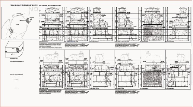
The reconstitution studies revealed various architectural features which no longer exist or became invisible at the site. The two terraces located to the northeast and southwest of the Tumulus have similar features as the inscription (Nomos) carved at the back of the colossal statues, the two stele rows depicting the Macedonian and Persian ancestors of Antiochos and the incense altars situated in the front of each stele. At the East Terrace, in front of the collosal statue row, there are two podiums in different levels reached by two stairs at the both ends, whereas, at the West Terrace there is only one podium situated on a lower level compared to the East one. At the East Terrace some evidences have been found showing that a row of steles including the lion horoscope similar to the west terrace are found, however, today no traces of these can be observed. In both terraces there are altars in front of the colossal statue row. In addition to these altars there is another sacrifice altar at the East Terrace on the front corner of the stepped pyramid. Again at the East Terrace on the stepped pyramid, Goell found stone pieces proving that there has been an altar structure with a pedimented roof of which the evidences can not be observed at site today. The row of steles without any relief situated at the North Terrace which show different characteristics form the other terraces was another curiosity for the researchers. General opinion is that the steles at this terrace were never aimed to carry any relief and this terrace should have been designed for ritual purposes which are unknown at the present.
There are two ceremonial ways reaching to the terraces. The traces of the ones reaching the East and West Terraces can be observed partially today whereas
there are no evidences of the north one. Some traces have shown that there is an entrance to the north terrace with an opening in the middle of the stele row and some guardian animals defining this entrance. There are two reception steles on the two ceremonial ways reaching the other two terraces; one located approximately 280 m to the northeast of the east terrace and the other one 112 m to the southwest of the west terrace. The steles have inscriptions on one side, whereas there is no evidence of a relief on the other side. There are no traces of such a stele at the north terrace.
The restitution of the Mount Nemrut Tumulus prepared by the contribution of D. Sanders can also be seen at the web site: http://www.learningsites.com/Frame_layout01.htm .
No definite date can be assigned to the construction of the Mount Nemrut Tumulus monuments. The inscription (nomos) carved at the back of the colossal statues, which states the testament of Antiochos I. concerning his wishes about this monument and the ceremonies to be held at the monument, mentions the day and month of construction but not the year. According to the inscription Antiochos’ date of succession to the throne is “Loos 10”, and his birth date is “Audnaios 16” which correspond respectively to July and December/February. The lion horoscope located at the west terrace has a great importance as it shows a significant date related to the site. Different researchers have expressed different dates and different events shown on the Lion Horoscope; however this question continues to be a subjet of research.
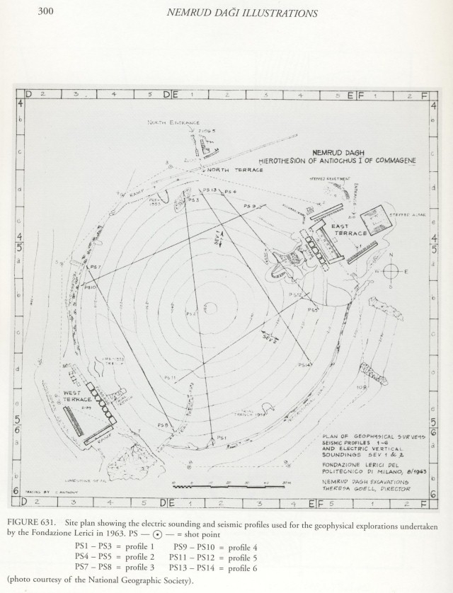
The geophysical researches which started in Goell’s period and repeated during Şahin’s period in 1988-1989 using the latest technologies, have revealed noteworthy information about the Tumulus’ inner structure, however no research has succeeded in finding the burial chamber to date.
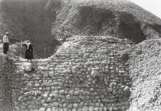
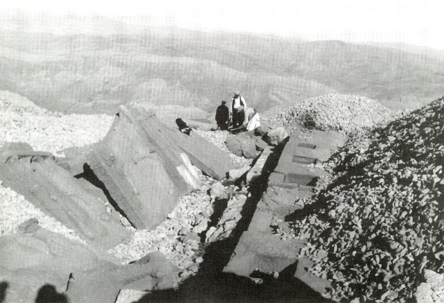
During Goell’s period, the excavations revealed that the Tumulus has a stepped inner structure constructed with rubble stones without mortar on the main rock; the form of this inner structure is defined by the help of geophysical surveys. Some hypotheses assert that the monument was never finished, thus there was no burial chamber underneath the tumulus; however there is no proof of this yet.


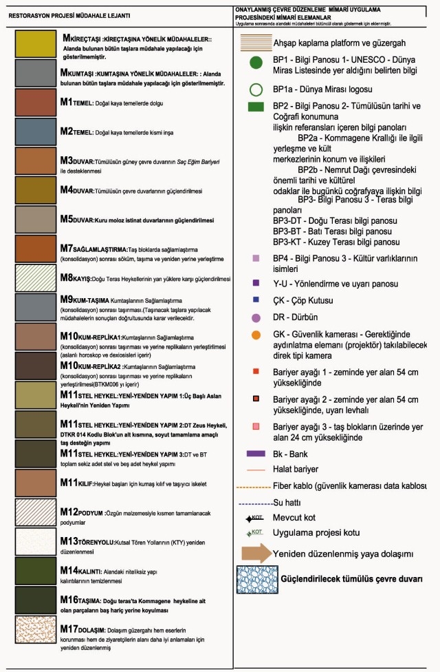
The consolidation project includes the material consolidation, conservation and repair interventions. The projects and reports are submitted to the Ministry of Culture and Tourism in January 2011 and approved by the Şanlıurfa Regional Commision of Cultural and Natural Assets on 26 October 2011.
Aim:
The Mount Nemrut Tumulus Consolidation Project which aims to protect and sustain the values and eliminate the problems threatening this ‘World Heritage Site’, has adopted these main conservation principles: to preserve the original, maintain integrity, reversibility, minimum intervention and conservation insitu.
Scope:
Mount Nemrut Tumulus conservation project comprise the below mentioned documents:
- Mount Nemrut Tumulus Conservation project report. Includes the conservation approaches, principles, intervention criteria stated in consideration with all documents compiled during the studies.
- Mount Nemrut Tumulus conservation project (12 drawings in 1/5, 1/10, 1/20, 1/50, 1/200 and 1/500 scales)
- Mount Nemrut Tumulus, conservation project, architectural blocks deterioration and intervention study (59 drawings prepared for 408 stone blocks)
- Mount Nemrut Tumulus conservation project, intervention drawings (7 drawings in 1/500 and 1/50 scales)
Principles, Main Conservation Approach and Adopted Intervention Criteria
The main conservation approach in the MNT conservation project can be stated as value based minimum intervention; conservation of the assets in their location 1887 as adopted formerly by T. Goell and K.F. Dörner; making few partial completions which aim to help perception of the area correctly only if exist historical references.
The aim is to enhance the integrity of the area, its meaning together with its physical aspect, material, technical and contextual originality. Therefore completion, rebuilding and reconstruction activities are avoided as much as possible. To achieve this aim, all the documents since nineteenth century are studied and the interventions made under insufficient knowledge and interpretations during this period are decided to be removed to their original status using the most reliable resources obtained. For the few reconstructions aiming to maintain the visual integrity at site, the design is so that it will be in harmony with the old but distinctive from the original in the choice of material, details and in the interpretation.
The following principles are adopted for the interventions defined in the MNT conservation project:
- Should enable the local people to understand and value the cultural heritage;
- Should aim communicate the ‘meaning’ and the ‘importance’ of the area to the different target groups;
- Should provide the protection of the tangible and intangible values within their natural and social context;
- Should be sensitive to the original character of the area;
- Should contribute to the sustainability of the area;
- Should introduce an approach which includes the varied stakeholders and promotes participation;
- Should define principles that are sustainable, consistent with the social context and should keep technically and professionally a leading role in the technology and research.
Interventions
The interventions in all scales are defined as the following:
Interventions
The interventions in all scales are defined as the following:
- All primarily aiming for minimal intervention, different approaches are adopted for each terrace which have different qualities and problems considering their original design, level of deterioration / destruction and presentation:
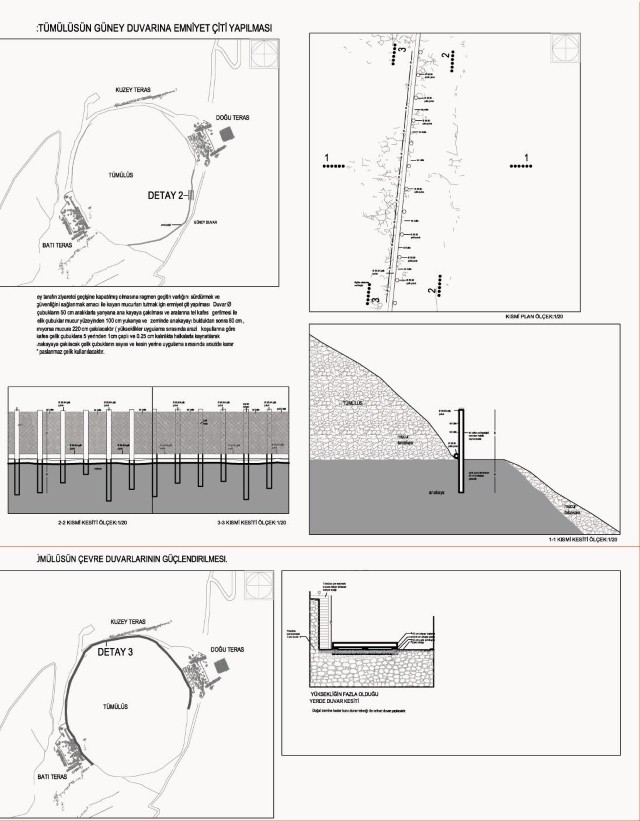
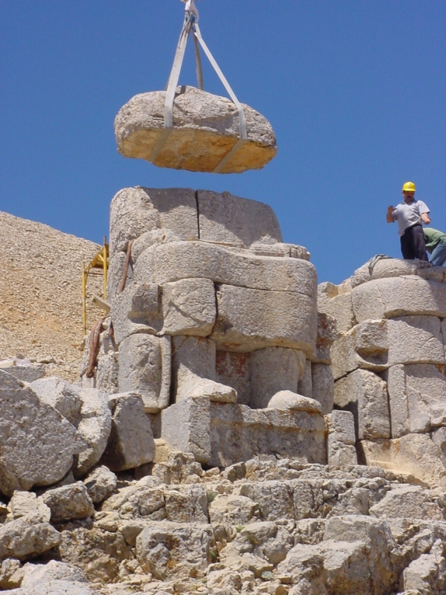
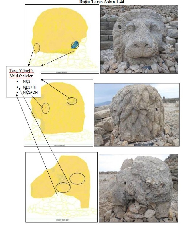
- East terrace: In the east terrace, which is better conserved compared to the west one, at first the structural problems will be solved and the material conservation interventions will be applied on the stone blocks. The replaced stone head blocks will be moved back to their initial places before the 2003 intervention in order to preserve and sustain the image formed in minds of the public since more than a hundred years. In addition to these interventions concerning the assets, landscape elements and a wooden platform planned to serve the disabled will be constructed for the visitors.
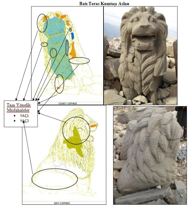
- West terrace: Urgent interventions of conservation to the stone blocks will be realized primarily. The present state of the terrace, the location of the statues and collapsed blocks will be conserved as they are. Only some lime mortar consolidation will be made under the statue blocks and on the natural rock base underneath the statues at the south section. The inscription at the back of the colossal statues will be opened to visit after constructing a protective barrier. The four Dexiosis steles which are located at this terrace and which constitute one of the most important features of Mount Nemrut Tumulus will be replaced by the replicas. The original steles which are today in the temporary restoration laboratory, will be cleaned, consolidated and removed to the Adiyaman Museum. The scattered stone blocks at the north end, the entrance to the west terrace from the processional way will be put in their original locations and the three headed lion statue will be set on these after completing the lacking parts only as a mass in an abstract way.
- North terrace: After the application of the urgent conservation measures on the sandstone blocks, the stone heaps and the rests of the later constructions at the terrace will be removed in this way the platform indicating the entrance of the north terrace and the natural stone wall aligning the processional way will become apparent.
- Sacred processional ways: The sacred processional ways reaching to the east and west terraces will be enhanced by constructing stone footsteps where the road tends to steepen. Stone blocks will be put all along the roads and sandstone replicas of the stele I and stele II on the east and west processional ways will be installed in their original locations in order to help perception of the road trail.
- Visitors’ route: The visitors’ route designed within the Environmental Design Project previously is revised such that it will pass behind the statues at the west terrace allowing the visitors to see the Nomos and perceive the ancient quarry.
- Although it is not considered as a threat today, during the sunrise and sunset hours the visitor numbers at one time in one terrace should be limited to a maximum of 450 people.
- The special conditions of the area and the result of the surveys especially concerning the preservation of the stone material revealed that the conservation implementations should be handled not as a one time activity but an ongoing process which has to be monitored and developed continuously. In this framework:
- The conservation process is defined as a series of actions listed under the title: Five Years Plan for the Conservation Implementations and Interventions in Mount Nemrut Tumulus.
- The conservation process is seen as an opportunity for the publicity of the area; it will also help raising awareness and job creation. The training program and the specifications of the staff that will work in the site during the five years period of implementation / conservation are defined.
- The monitoring activities which should be continuing during the conservation period are defined.
- According to the above mentioned framework the intervention criteria for the conservation of Mount Nemrut Tumulus are:
- All interventions will be in harmony with the original material and construction techniques. New details compatible with the original may be developped for some small interventions where the original techniques are insufficient. These interventions will be done using limestone and sandstone material and will be distinct from the original in the architectural details (like bosages or date carvings on the stone surfaces). All later interventions will be communicated to the visitors by the use of booklets and exhibitions.
- The blocks which are under risk due to their location or some possible threats (like earthquake, snow load etc) may be displaced in the site.
- All necessary safety precations should be taken during the interventions.
- During the consolidation procedure it is essential to keep the site open to visit. All intervention works, site staff and physical activities will be planned accordingly. The site will continually be open to visit except during some interventions which may create risk for the visitors (like transportation of big stone blocks etc), in this case a short period of partial closure may be foreseen.
All consolidation interventions explained in general terms above are defined and planned under the main titles below:
1. Material conservation interventions
1.1. Interventions for limestones and sandstones
1.2. Main intervention principles for stone material
1.3. Intervention details considering limestone
1.4. Intervention details considering sandstone
2. Structural interventions
2.1. Base repair works
2.2. Consolidation and completions in Tumulus’ periphery wall and the other retaining walls
2.3. Consolidation and risk prevention interventions in architectural elements
3. Interventions according to architectural necessity
4. Interventions aimed for the presentation of the site
5. Monitoring and training activities
5.1. Stone consolidation research team training activities
5.2. Monitoring activities for consolidation (these are included within the Mount Nemrut Management Plan)
5.3. Stone maintenance, intervention, monitoring and training programs for monumental scale
6. Appendices
7. Tecnical specifications (6 items)
8. Static calculations report for conservation interventions